As of the 14 of March 2023, this thread has been archived. To see future updates on Syria, see our latest news section and for more information products, check out our REACH Syria page
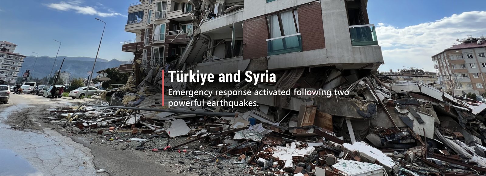
Two powerful earthquakes struck south-eastern Türkiye within a span of 12 hours on the 6th of February. The first, with a magnitude of 7.7 and epicentre near the provincial capital of Gaziantep, occurred in the early morning as most people still slept; the second earthquake (7.6 magnitude) followed whilst search and rescue operations were already underway.
Estimates indicate more than 34,000 people have been killed as of 13 February across both southeast Türkiye and bordering areas of northwest Syria, although the death toll is expected to continue rising. The earthquakes have also caused significant destruction, such as collapsed residential buildings and damage to critical infrastructure including gas pipelines. Widespread damage to homes and energy infrastructure is particularly concerning given the harsh winter conditions currently felt in these areas.
In the immediate aftermath of a disaster of this scale, rapid and reliable information is both in very high demand and low supply. To support the humanitarian response in Türkiye and Syria, IMPACT has deployed data gathering and analysis capacities to provide aid actors with timely information. This includes using earth observation and remote sensing techniques to gauge the extent and severity of damage across affected areas, as well as launching rapid needs assessments to help responders target lifesaving assistance to people who have been impacted.
Over the coming days and weeks, we will publish additional maps and other rapid information products here on our Türkiye-Syria Earthquake Response thread. Follow along for insights and analysis on how the crisis is evolving. For more information products, check out our REACH Syria page or create your own REACH alert subscription to receive updates from our work.
14/03/2023 – Analysing flood risk in earthquake affected areas of northwest Syria
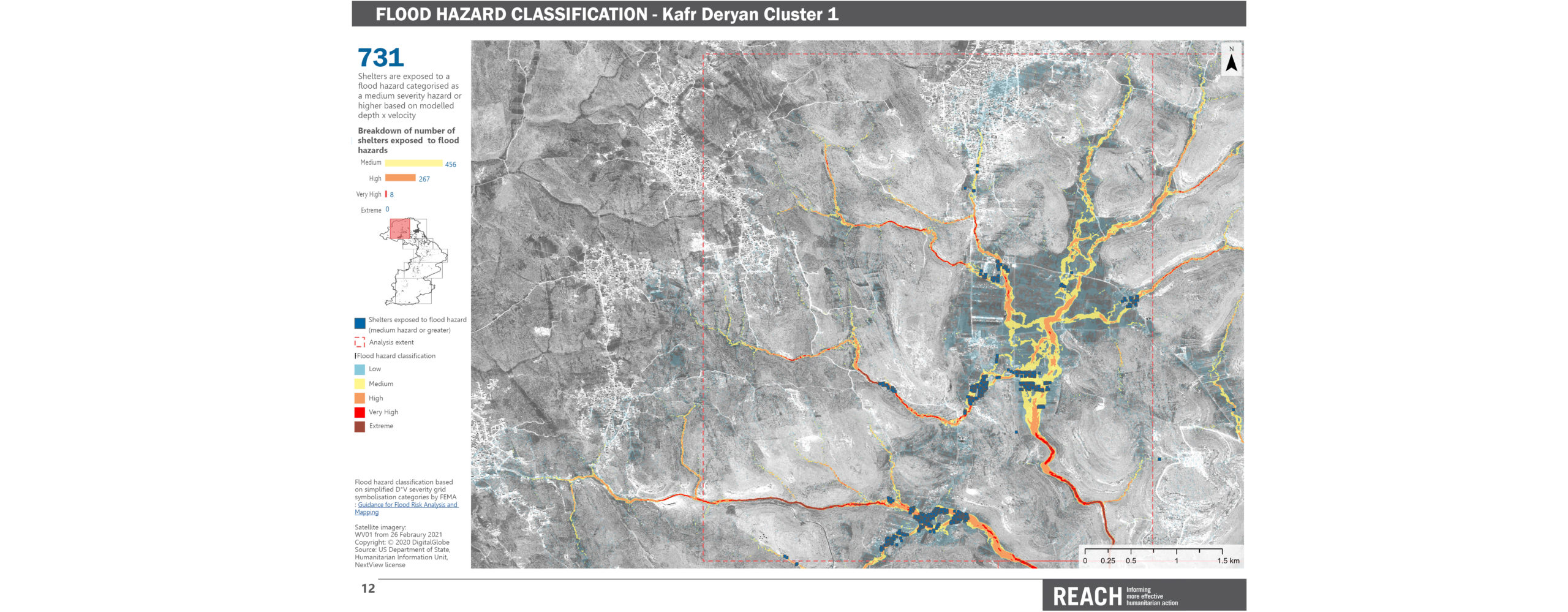
According to the notice issued by World Meteorological Organization on 13 March, severe showers and thunderstorms are expected this week in northwest Syria, indicating a risk of flash floods. IDPs located in last resort sites* are especially in danger, as they are likely residing in shelters that are less resilient to extreme weather and flood impacts.
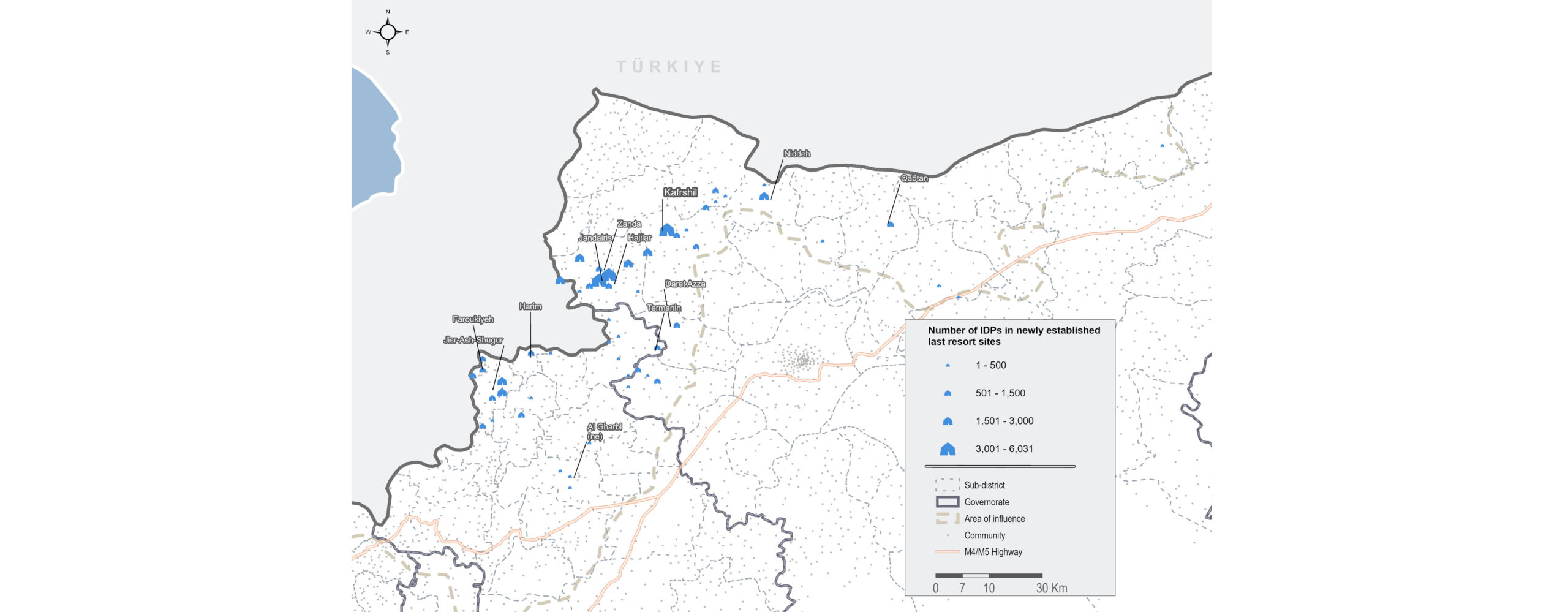
To support aid actors in identifying at-risk camps and shelters, REACH has previously conducted detailed Flood Hazard Assessments for Dana and Maarat Tamsrin sub-districts, which host 1.2 million individuals in last resort sites. In addition, our recent earthquake displacement assessment conducted in partnership with the CCCM Cluster indicates 7,400 IDP arrivals to last resort sites in Dana and Maaret Tamsrin since the earthquakes.
Findings from the Flood Hazard Assessments, including maps presenting flood hazard severity classifications and estimated numbers of exposed shelters, are available on the REACH Resource Centre:
Partners are invited to contact REACH for more detailed information, including hydrological model data in GIS formats for flood risk areas.
*Last resort sites include planned camps, self-settled camps, reception centres, temporary sites, and collective centres.
10/03/2023 – Key findings from the REACH displacement monitoring assessment in northwest Syria
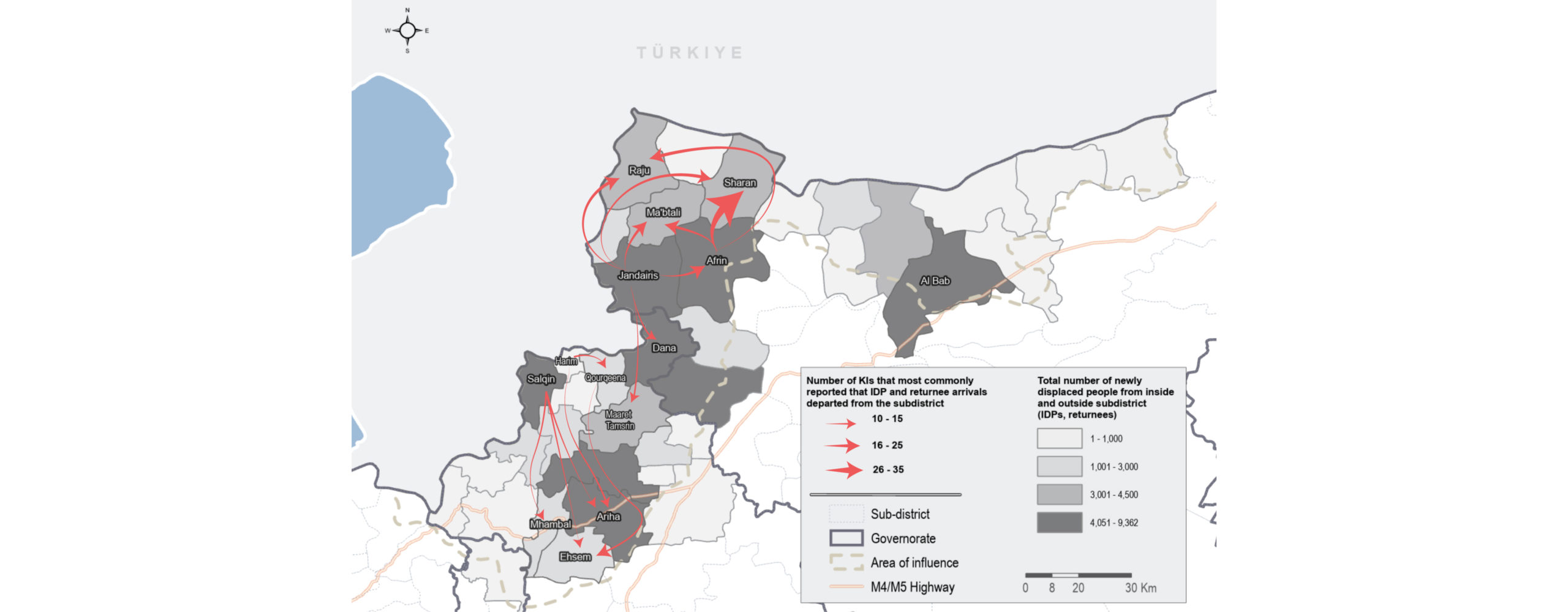
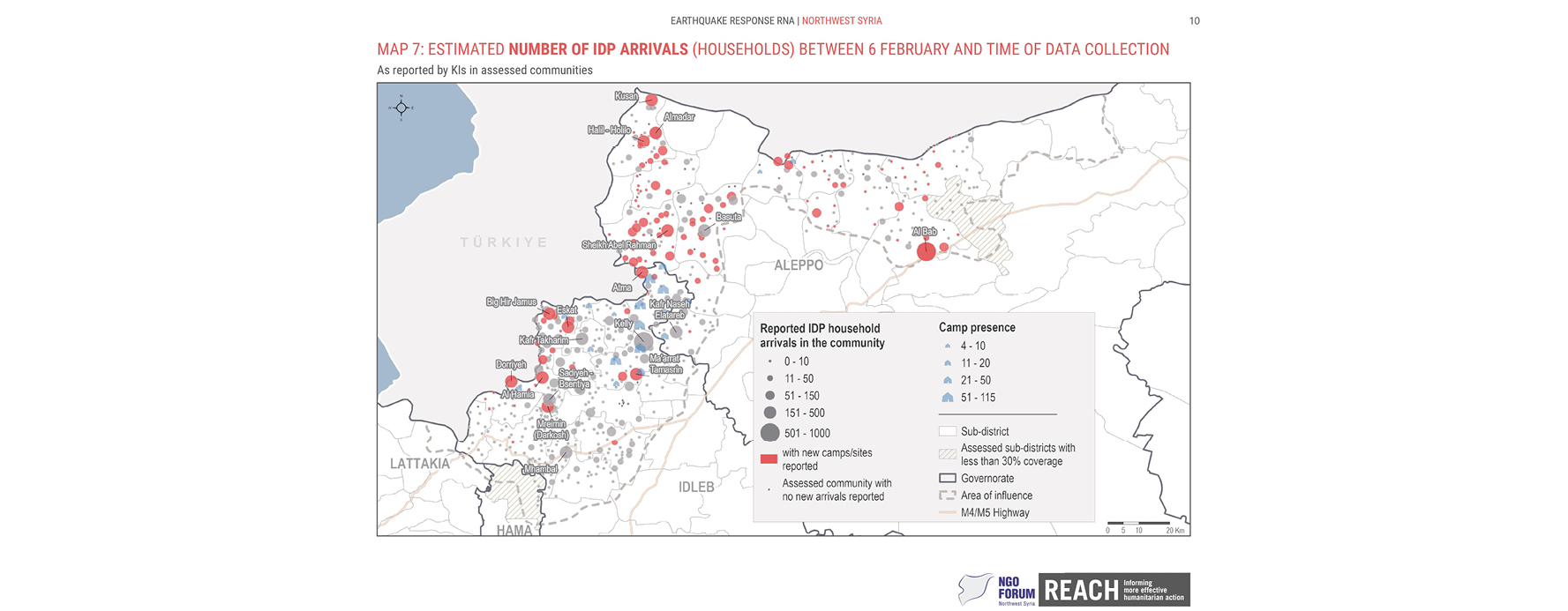
Widespread displacement has been reported in northwest Syria following the 6 February earthquakes. At the same time, there are reports of significant numbers of returnees arriving from outside Syria. Displacement movements after the earthquake are complex and often temporary in nature: whilst some households are displaced as a result of the direct damage, others may be visiting family or seeking better access to services or humanitarian assistance. In addition, displacement within communities has been reported with affected households residing outside of their homes.
To support humanitarian actors in developing a better understanding of displacement dynamics, REACH conducted a rapid displacement monitoring assessment from 28 February to 4 March. Our latest factsheet features key findings from the assessment, combined with data collected by the CCCM Cluster and partners on 2 March.
The assessment found that since the first earthquake:
- 103,472 IDPs arrived to communities and last resort sites
- 47,250 returnees and cross-border movements have occurred
- 91 last resort sites* have been established
*Last resort sites include planned camps, self-settled camps, reception centres, temporary sites, and collective centres.
The top reported push factors for new IDPs and returnees included damaged or destroyed houses, feeing unsafe due to the earthquake, and reduced access to food. Most commonly reported pull factors included family ties or relationships with the host community, locations that were less impacted by the earthquake, and locations that were perceived as being more secure or less affected by conflict.
08/03/2023 – IMPACT’s support to the Multi-Sector Initial Rapid Assessment in Turkey
As an operational partner of the UN Disaster Assessment and Coordination (UNDAC) mechanism, IMPACT contributed to the recent Multi-Sector Initial Rapid Assessment (MIRA) in earthquake-affected areas of Turkey. More than 30 partners from national NGOs, international NGOs, UN agencies and IFRC/Turkish Red Crescent contributed to the MIRA, supporting in conducting interviews in 120 districts (ilçeler) across 11 provinces. As a result, more than 500 key informants were interviewed in one week.
Following data collection, partners came together for a joint analysis workshop last week, hosted by the Turkish Red Crescent in Ankara. Key sectoral and inter-sectoral findings were discussed by participating organizations and sectoral experts, with the resulting analysis expected to feed into humanitarian response planning and coordination processes.
[metaslider id=”64056″]
07/03/2023 – JRAM in context: pre-earthquake market conditions, livelihoods, and food security in northwest Syria
The Joint Rapid Assessment of Markets (JRAM) conducted last month provided a critical understanding of how the earthquakes have impacted market conditions and availability of high-demand shelter and winterisation items in northwest Syria. Findings from the assessment have been used by operational actors to inform planning and delivery of urgent humanitarian assistance.
To complement the JRAM analysis, our latest REACH advocacy brief zooms out a bit further, to put current market dynamics in a wider context. Drawing on analysis of both pre- and post-earthquake conditions, the brief highlights three key messages:
- Markets in northwest Syria appear resilient following the 6 February earthquakes. Most assessed communities reported that shops were largely open; on average, shops which had closed immediately after the disaster were reopening several days later. However, this resilience should not be assumed indefinitely, given the longstanding financial pressures being faced.
- Vendors reported market shortages and price increases for key high-demand items after the earthquake. In particular, prices for shelter and winterization items have nearly doubled across NWS. Items most commonly facing shortages were also those most commonly reported to be imported from Türkiye.
- Affordability of basic food and non-food items remains a challenge for households, due to years of conflict and deepening economic crisis. REACH data found increased demand for purchases on credit and access to financial services post-earthquake, which can’t be met by struggling vendors who are themselves in need of cash. This is within a broader context of economic instability and widespread poverty in NWS.
23/02/2023 – Key findings from the Joint Rapid Assessment of Markets in northwest Syria
Understanding market dynamics in northwest Syria has become critically important as humanitarian organisations work to determine how to procure, transport, and deliver urgent assistance to people in need while facing access and transit challenges. One key consideration right now is the viability of cash assistance, to mitigate some of the logistical challenges associated with in-kind aid.
While a primary advantage of cash-based assistance is the agency afforded to crisis-affected people, who are able to decide what they need most and then purchase those items directly, market functionality and access are key factors for determining if cash-based approaches to aid are feasible. If markets are damaged or destroyed, or are unable to maintain stock due to broken supply chains, then operational actors will take this into consideration before proceeding with cash programming.
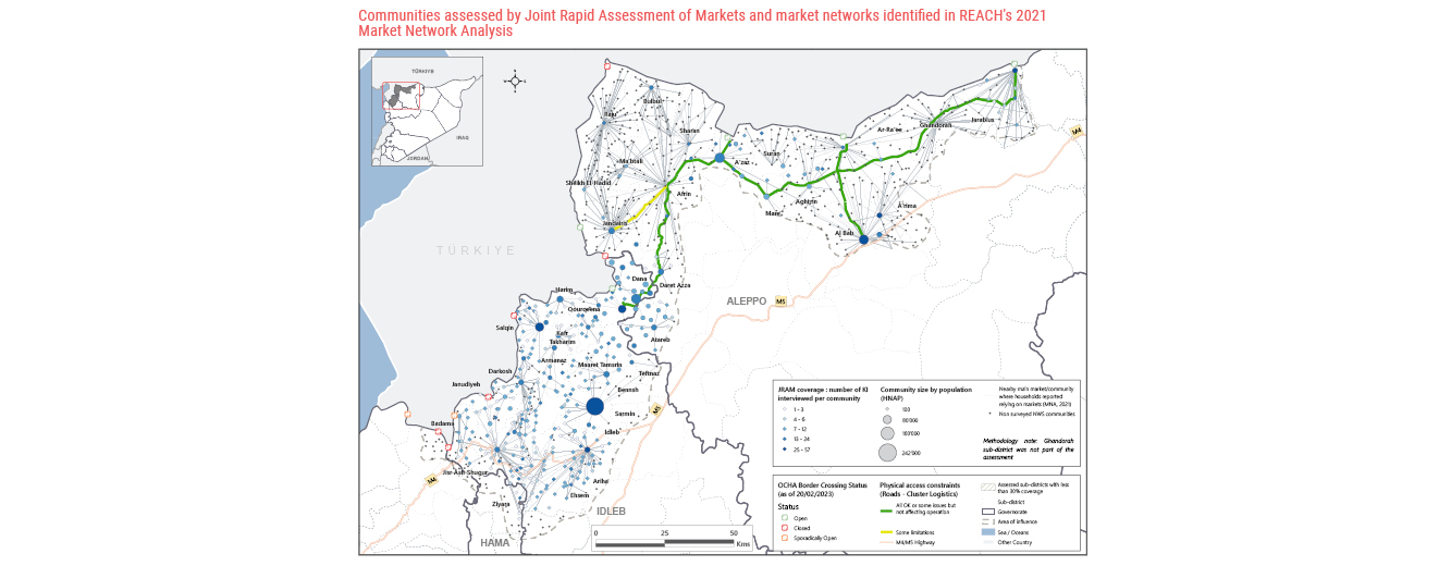
To inform the design and implementation of cash and market-based programming by humanitarian actors responding to the earthquake in northwest Syria, REACH conducted a Joint Rapid Assessment of Markets (JRAM) from 14 to 16 February, in collaboration with the NWS Cash Working Group and NWS NGO Forum. Enumerators interviewed 3,395 vendors across 375 communities, with 10-12 vendors interviewed per market, to build an indicative picture of market functionality trends.*
Overall, the JRAM analysis found that:
- Assessed markets across NWS broadly remain open. In the vast majority of assessed communities (73%), interviewed vendors reported that either all vendors were operating or only a few vendors were closed.
- Financial service providers are reportedly operating in over two thirds of assessed communities. However, in approximately a third of assessed communities KIs reported that these services would have limited or no capacity to meet increased demand.
- Demand for credit in their stores has increased in more than two thirds of assessed communities since the earthquakes. The same communities that reported increased demand for credit also reported reduced capacity to allow purchases on credit.
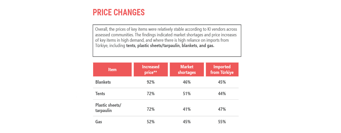
- The findings indicate market shortages and price increases of items in high demand, and items for which there is high reliance on imports from Türkiye, including tents, plastic sheets/tarpaulin, blankets, and gas.
- KI vendors reporting barriers to meeting greater demand said that lack of resources in addition to insufficient stock from suppliers and producers prevents them from meeting demand.
* Note on JRAM methodology: The assessment employed a ‘key informant’ methodology, meaning that findings are only indicative and not statistically representative of the assessed communities or wider region.
For more in-depth analysis of JRAM findings with infographic maps, check out our just-published Situation Overview. A JRAM dashboard, shorter key findings brief, and full dataset are also available for download.
21/02/2023 – Summing up the RNA findings, yesterday’s earthquake, and what’s next
A complete set of analysis and information products is now available, providing key takeaways from the Rapid Needs Assessment conducted by REACH in partnership with the NWS NGO Forum on 9-11 February:
- (Published today) RNA global brief: Provides quick, top-line takeaways from the RNA to summarize the situation two weeks after the 6 February earthquakes.
- RNA situation overview: In-depth overview of the RNA findings, providing key data for coordination and emergency response actors on the ground.
- Community and sub-district level dashboard: For easier exploration of individual indicators of interest and visualisation of the results at community or sub-district levels.
- HTML analysis file: Provides additional analysis of the RNA data, aggregated to the NWS and sub-district levels.
- Datasets: The complete community-level data from the RNA is publicly available in English and Arabic.
20 February earthquake:
Two weeks after the initial disaster, another earthquake registering 6.4 magnitude struck southeast Turkey near the city of Antakya, raising concerns over new damage in areas already devastated by the 6 February earthquakes. This latest quake suggests an ongoing vulnerability to these shocks in the region.
Upcoming REACH data and analysis:
REACH has conducted a Joint Rapid Assessment of Markets (JRAM) in collaboration with the Cash Working Group, to gain a more in-depth understanding of market conditions and implications for cash-based programming. Preliminary results are anticipated to be released tomorrow, with more detailed analysis after that. Follow this thread for updates on the release of these new products.
16/02/2023 – 10 days after the earthquakes: What we know about the situation on the ground
As the humanitarian response continues following the deadly earthquakes 10 days ago, aid actors are starting to build a clearer picture of the situation on the ground. With data coming in from information actors, the response increasingly has a better understanding of which areas have been most impacted, what types of services are disrupted, and what are the most immediate, urgent needs of people in earthquake-affected areas.
Here is what we know about the current situation, according to the latest analysis from the northwest Syria Rapid Needs Assessment (RNA), conducted by REACH in partnership with the NWS NGO Forum on 9-11 February:
- 55,000 households (approx. 302,500 individuals*) are estimated to have been displaced, either within their community or from it.
- 50,000 households (approx. 275,000 individuals*) are estimated to be in need of tents or emergency shelter at a collective centre.
- 88,000 households (approx. 484,000 individuals*) are estimated to be in need of mattresses, high thermal blankets, and clothing, to cope with extreme winter conditions.
* Estimated number of individuals is calculated based on an average household size of 5.5 people.
Eighty-five percent of assessed communities (covering about 60% of earthquake-affected areas) are reported to either be directly impacted by the earthquake – damage and/or service disruption – or have received new arrivals of displaced people. Among the directly impacted communities (456 in total), severe disruption to key services has been reported:
- 28% of communities reported that electricity services were not accessible to anyone in the community; 20% reported the same for health services.
- 15% of communities reported that water services were not accessible to anyone, or were accessible to only a few (less than half of the community).
- Badama, Harim, and Judiyeh are the three sub-districts reporting the most severely disrupted access to services, according to the severity scores calculated in the RNA analysis – see yesterday’s post for more details.
These findings are concerning – not only because they underscore the imminent need for aid to earthquake-affected communities, but also because of the high vulnerability of people residing in northwest Syria prior to the disaster.
For example, a reported lack of access to health and water services in the RNA is particularly troubling given the ongoing cholera outbreak in the country and generally weakened health infrastructure due to years of armed conflict. According to OCHA reporting from 18 January, “over 2.1 million people in northwest Syria live in the most at-risk subdistricts for developing a cholera outbreak”; as of 14 January the region had recorded 555 lab-confirmed cholera cases and 20 deaths, with more than 37,700 suspected cases reported in both Idleb and Aleppo governorates.
The country has also been facing a serious economic crisis over the past year, due to currency depreciation and rising prices – in greater Idleb, this translated to higher costs for key necessities like food, fuel, and hygiene items. Additionally, according to our last humanitarian situation monitoring in December 2022, most communities in the greater Idleb area were reporting barriers to accessing sufficient food, access to healthcare remained unaffordable for many, and winterisation needs – particularly heating fuel – was already being raised as a top priority for both IDPs and host communities.
It is therefore crucial for aid actors to keep in mind the pre-earthquake baseline of conditions in northwest Syria that were already alarming, as they use incoming needs data to inform their response planning.
—
Want to view more RNA results? Check out our just-published Situation Overview, dashboard, and community webmap.
15/02/2023 – Analysis of earthquake damage and access to services using RNA data
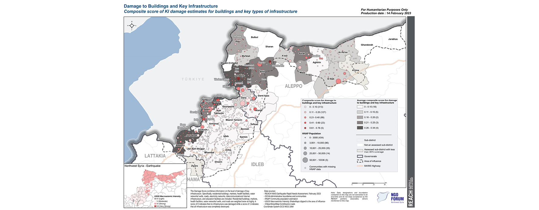
Following the Rapid Needs Assessment (RNA) conducted 9-11 February, REACH has produced two new maps to highlight which communities in northwest Syria have been most impacted in terms of earthquake damage and access to services. Generally, subdistricts close to the Türkish border in Greater Idleb and in Afrin district in Northern Aleppo saw higher levels of damage to buildings and infrastructure, on average.
Zooming in to the community level, Jandairis and Mreimin Afrin have some of the highest damage scores. Several higher-population communities are also estimated to have moderate-high damage, for example Al Bab, Tharifa, and Salqin.
The damage score was calculated using RNA data on the level of damage to key infrastructure: residential buildings, markets, health and education facilities, water networks/wells, roads, and electricity and telecoms networks. The score is calculated on a 0-1 scale, where 0 indicates no damage and 1 indicates complete destruction.
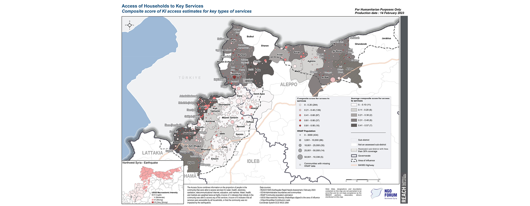
Particularly in parts of Greater Idleb on the Türkish border and throughout Northern Aleppo, there were widespread issues with households being unable to access key services. Specifically, Badama, Harim, and Janudiyeh subdistricts stand out with higher severity of access scores. These areas also saw higher damage scores. At community level, Jandairis town again has among the highest severity scores.
Across all assessed areas, the RNA found that 22% of communities reported half or fewer households had access to water services, 31% reported the same for sanitation, and 49% reported the same for markets. Note: according to the RNA methodology, one ‘key informant’ per community was interviewed, therefore results are indicative only and not statistically representative of the whole community.
The severity of access score was calculated using data on the proportion of people in the community that were able to access services for water, health, sanitation, markets, education, electricity and telecoms.
14/02/2023 – Preliminary results from the REACH RNA in northwest Syria
In the week following the deadly earthquakes, critical information gaps remain for humanitarian actors responding in northwest Syria. Whilst emergency response is ongoing, aid actors require a more comprehensive understanding of which communities have been most severely impacted and how, in order to more effectively target assistance where needs are greatest.
To address these information needs, REACH conducted a Rapid Needs Assessment (RNA) from 9 to 11 February, in collaboration with the northwest Syria (NWS) NGO Forum. Data was collected across 604 communities in Greater Idleb and Northern Aleppo.
Key findings from the RNA
- Overall impact: Around 75% of assessed communities are estimated to be impacted by the earthquake in terms of damage and/or service disruption.
- Displacement: The presence of new IDP arrivals since the earthquakes was reported in nearly half (271) of assessed communities. Based on best-guess estimates, the number of new arrivals across these communities is roughly 14,711 households and upwards of 80,900 individuals (assuming an average household size of 5.5 members).
- Priority needs: For both new IDP arrivals and the pre-earthquake populations in these communities, priority needs are the same: shelter support, multi-purpose cash, and winterisation support.
- An estimated 50,000 households were reported to be in need of tents and/or emergency shelter at collective centres.
- An estimated 90,000 households were reported to be in need of mattresses, thermal blankets, and clothing.
It is important to emphasize that people in these communities were already experiencing high levels of vulnerability and prior cycles of displacement before the earthquakes, due to the ongoing effects of the conflict, including strained health services and weakened infrastructure, as well as a spiralling economic crisis.
Note on RNA methodology: One ‘key informant’ or KI – a person with particular knowledge or a good understanding of the situation on the ground – was interviewed per community. In sudden onset emergencies, KI data collection methods are often chosen in order to gather basic information about a large area very quickly. However, with a single person responding on behalf of a community, it is important to keep in mind that these findings are intended to provide an indicative picture of the situation only and are not statistically representative of the target population.
Zoom-in on market conditions
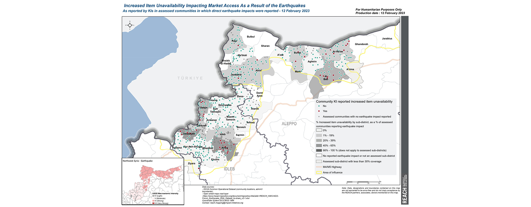
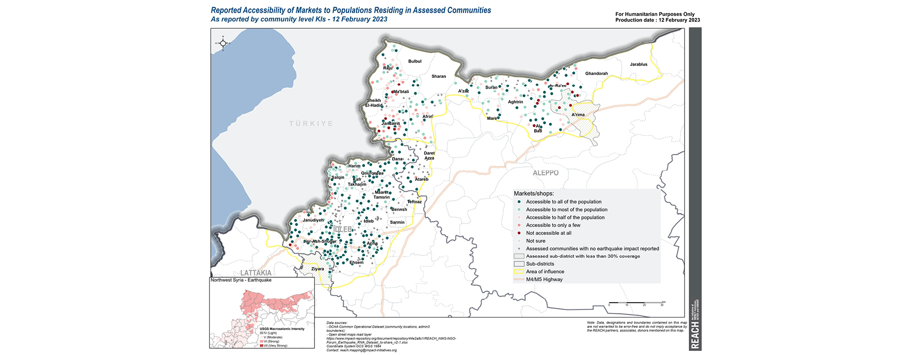
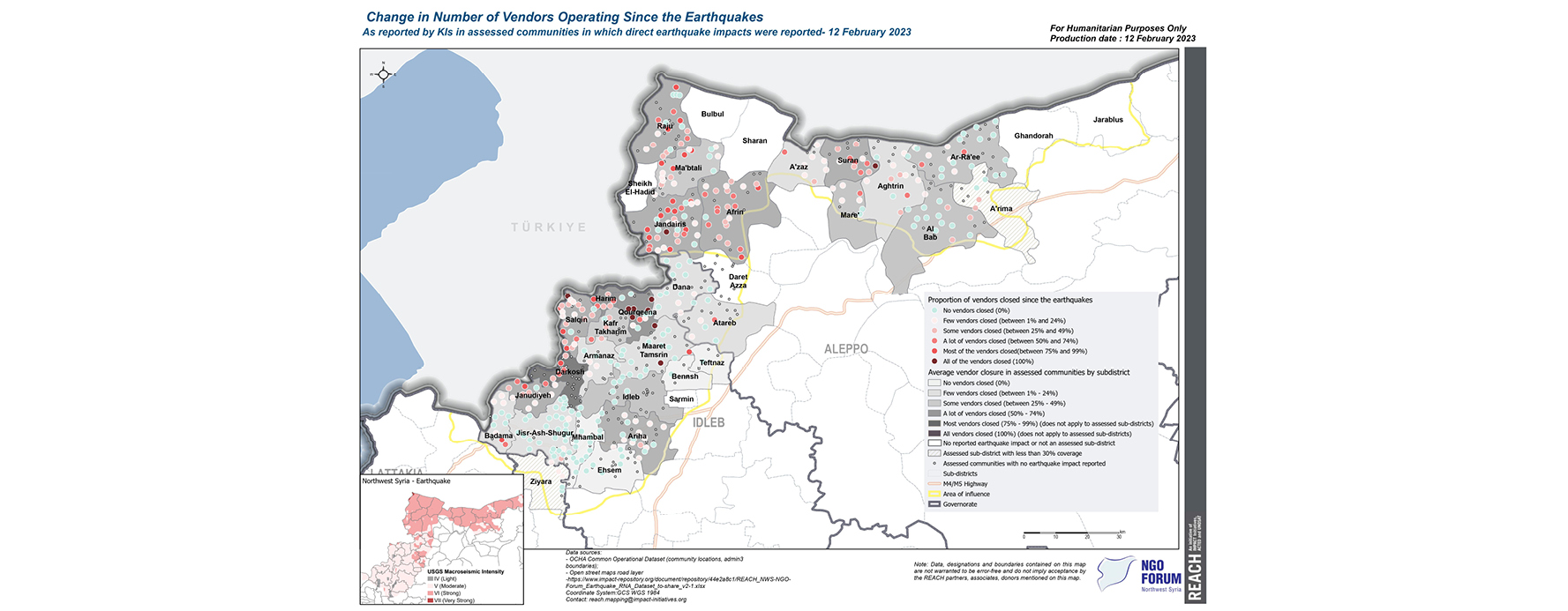
Several key market indicators were collected through the RNA, to support ongoing efforts to identify where cash-based programming may be a feasible aid modality. Preliminary analysis from three key indicators suggests that overall, markets in the assessed communities appear to be resilient.
- Item availability: In assessed communities that reported direct earthquake impact (i.e. damage or service disruption), an increased unavailability of items was not commonly indicated as an issue (reported in only 11% of communities). However, increased item unavailability was more commonly reported in Ariha and Janudiyeh sub-districts, and to an extent in Salqin, Al Bab, and Ar-Ra’ee sub-districts.
- General market accessibility: Markets were generally accessible to all or most of the population in directly impacted communities, according to KIs in 79% of communities. Sub-districts where markets were only reported to be accessible to half or less of the community included Janudiyeh, Ma’btali, Raju, and Jandaris.
- Vendor/shop closure: In two-thirds of communities, KIs reported that either none or only a few of the vendors had closed shop since the earthquakes. However, a higher proportion of shop/vendor closures was estimated in Darkosh, Harim, Qourqeena, and Suran sub-districts.
It is important to note that the market situation remains fluid, and may evolve given ongoing access constraints in NWS. To continue assessing the situation and provide more in-depth information regarding market access and functionality, REACH will be conducting a Joint Rapid Assessment of Markets (JRAM) next week, with preliminary results anticipated to be shared around 20th February.
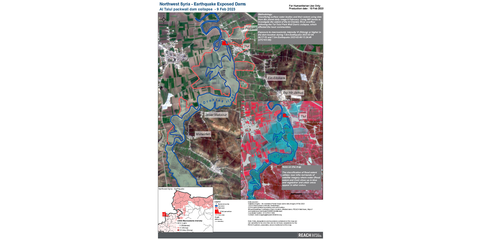
12/02/2023 – Damage to dams and flood risk in northwest Syria
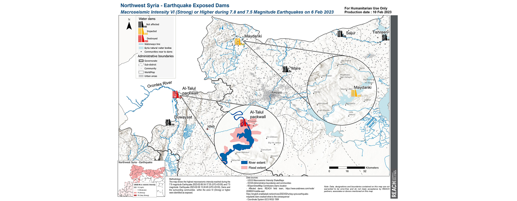
Six dams are located within the earthquake-affected areas of northwest Syria, which triggered immediate concerns about potential structural damage and flood risk in communities that had been devastated by last Monday’s quakes.
These fears became a reality on Thursday, when cracks in the Al Talul packwall dam gave way, following intense rains that swelled the Orontes River and subsequently flooded the town of Al Talul. As a result, more families have been displaced following the floods, in an area that has not only been impacted by the earthquakes, but has also been coping with the effects of over a decade of armed conflict.
To support emergency response actors in identifying further risks to dams, REACH has produced two new maps depicting dam locations and their earthquake exposure.
The first map provides an overview of all six dams in the northwest, highlighting Maydanki dam in the northern Aleppo area as having been impacted.
The second map zooms in on the Al Talul packwall dam collapse, highlighting the extent of flooding and proximity to nearby communities.
10/02/2023 – Market functionality: A critical factor for determining the right aid modality
Following Monday’s earthquakes, humanitarian organisations are working to determine how to procure, transport, and deliver urgent assistance to people in need, while facing access and transit challenges. One key consideration at the moment is the viability of cash assistance, to mitigate some of the logistical challenges associated with in-kind aid.
While one key advantage of cash-based assistance is the agency afforded to crisis-affected people, who are able to decide what they need most and then purchase those items directly, market functionality and access are key factors for determining cash feasibility. If markets are damaged or destroyed, or are unable to maintain stock due to broken supply chains, then operational actors will take this into consideration before proceeding with cash programming.
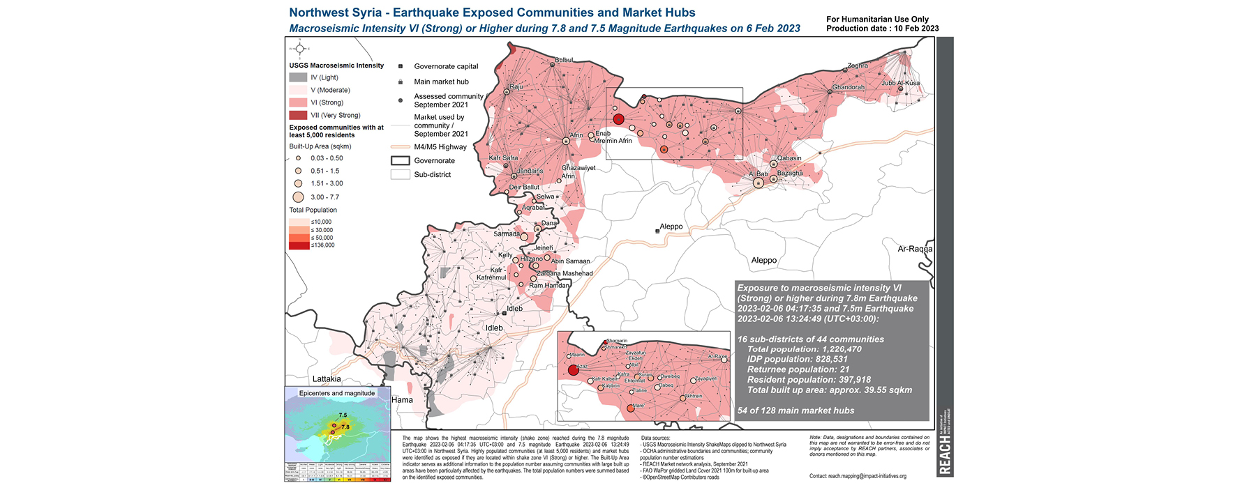
To support ongoing decision-making around cash feasibility for the earthquake response, REACH produced a new market analysis map. This map shows northwest Syria’s key market hubs and the communities they served pre-earthquake, overlaid with earthquake exposure. According to this analysis, a number of the largest market hubs are located in the ‘strong intensity’ earthquake-affected areas, indicating likely damage; however, preliminary results from the REACH RNA (with data collected from over 370 communities so far) suggest that for now, markets in these areas are resilient.
More questions remain about the extent of damage to markets, where they remain functional, what items are available, and whether people can access them. To address these critical information gaps, REACH is launching a rapid market assessment next week. Follow this thread for updates on the assessment and publication of key findings.
09/02/2023 – 72 hours in: Mobilising to address urgent data gaps
Information actors have quickly mobilised to support operational planning and provide a wider understanding of the situation on the ground. REACH teams are leveraging available data to produce timely maps depicting earthquake exposure, whilst also launching a coordinated, inter-agency rapid needs assessment (RNA) to fill key data gaps in Northwest Syria – where information about the impact of the earthquakes is reportedly more limited.
Spatial analysis products provide a vital snapshot of conditions
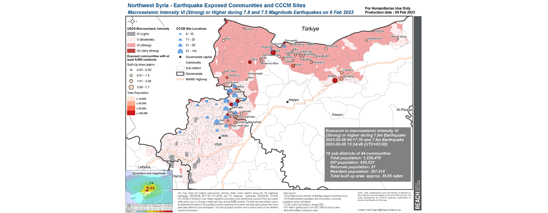
Our latest map shows locations of displacement sites managed by the Camp Coordination and Camp Management (CCCM) Cluster, as well as highly populated urban communities that are within the earthquake exposure zone. According to this analysis, most CCCM sites in the earthquake-affected areas are clustered in greater Idleb, where macroseismic intensity was registered as moderate to strong. Several high-population cities and towns, including Afrin, Azaz, Al Bab, Dana, and Sarmada, are located within strong-intensity areas.
Camps and sites within the exposure zone are particularly vulnerable, as tents are a primary form of shelter, and other basic infrastructure may be less secure. Urban areas are also a concern, due to the higher likelihood of severe damage and risks to people’s safety in densely populated areas.
Other shock exposure maps published to date:
- Reference map (printable in A0 size): Earthquake exposed communities in NWS, macroseismic intensity IV (light) to VII (very strong)
- Earthquake exposed communities in NWS, macroseismic intensity IV (light) to VII (very strong)
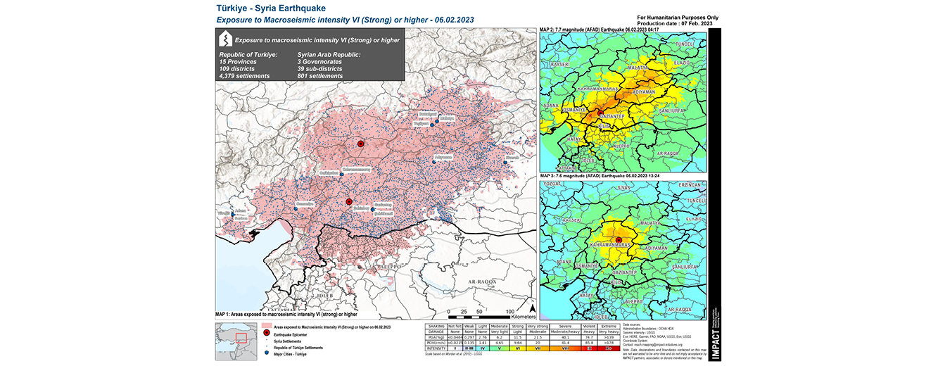
- Exposure to macroseismic intensity VI (Strong) or higher in Türkiye and Syria
Gathering real-time data on needs through the Northwest Syria RNA
In partnership with the Northwest Syria NGO Forum, REACH and partner agencies launched a Rapid Needs Assessment (RNA) today, with data collection planned through 11 February. The RNA will cover approximately 600 communities in Greater Idleb and Northern Aleppo, by interviewing community “key informants” (KIs) with a good understanding of the current situation and immediate needs of affected people. The RNA will provide urgently needed information about damage levels, shelter conditions, market access, priority needs, and barriers to accessing humanitarian aid, complementing secondary data analysis from other information actors.
Follow this thread for updates on the assessment and publication of key findings.
08/02/2023 – Zoom-in on Northwest Syria: Earthquake exposure in an already-vulnerable region
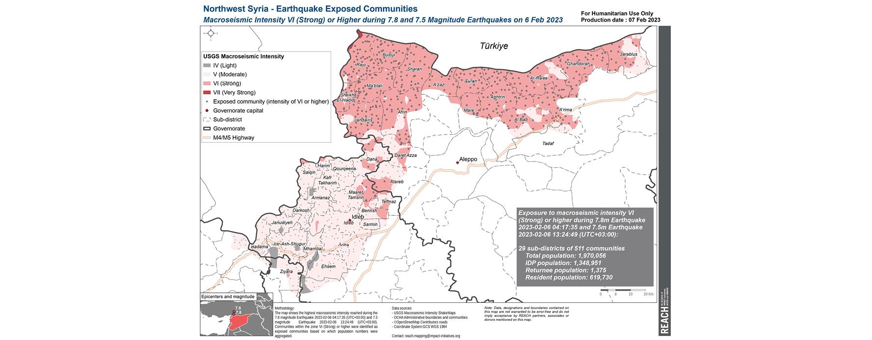
According to UN estimates, 4.1 million people in northwest Syria were already in need of humanitarian assistance prior to this disaster, due to more than a decade of armed conflict. Within the northwest, the Greater Idleb area is among the most vulnerable: 1.9 million out of its estimated 3 million residents are internally displaced, basic services including health facilities and water infrastructure have been weakened due to the ongoing conflict, and in the past year, an economic crisis has unfolded following rapid currency depreciation and rising prices.
In support of emergency response planning and coordination efforts, REACH produced a map showing earthquake-exposed communities in Northwest Syria.
The map shows the highest macroseismic intensity as an indicator for the feeling of shaking reached during the two earthquakes. Communities within shake zone VI (Strong) or higher were identified as exposed communities. Based on all exposed communities, the population numbers were summed.
Moving forward, REACH is planning to contextualize the current exposure map with data on urban areas, camps, informal settlements, and collective centres. REACH will also integrate these datasets into an interactive web map which will also present key findings from the upcoming Rapid Needs Assessment.
07/02/2023 – First 24 hours: Understanding the extent of earthquake exposure
In the first 24 hours following the earthquakes, IMPACT – an operational support partner of the UN Disaster Assessment and Coordination (UNDAC) mechanism – produced an infographic map depicting the number of communities exposed to strong-violent earthquake intensity, where structural damages are most likely to have occurred.


