
Launch Statement
IMPACT Initiatives commits to informing climate change related risks
for crisis-affected populations around the world
2020 was the warmest year ever recorded across the globe. Before that, the ten warmest years on record occurred between now and 1998. Nine of those happened directly after 2004. Human activities are responsible for driving climate change at an unprecedented pace. These rapid changes are creating an increase in the frequency, and intensity, of natural hazards such as such as storms, floods, droughts, and extreme temperatures as well as provoking a rapid decline in global biodiversity. From 2000 to 2019, disasters are estimated to have resulted in close to 3 trillion USD of global economic losses. In parallel, the global adaptation commission estimates that investments of 1.8 trillion USD in adaptation measures would return more than 7 trillion USD in avoided costs and other benefits. Poor and fragile countries are at the forefront of this global crisis. The Germanwatch Climate Risk Index shows that out of the ten countries most affected by extreme weather events, seven are among the least developed countries in the world. In 2021, once again the global risk report from the World Economic Forum has ranked failure to act on climate as one of the biggest threats to society.
There are immediate life-threatening manifestations of this global crisis: decrease in food security, increase mortality from water and air pollution, or disaster induced displacement. There are also cascading consequences. For example, competition for dwindling resources is exacerbating tensions between nations and communities, increasing the risk of violent conflict. And finally, persistent inequality compounded by COVID-19, means that vulnerable households in the world’s poorest and fragile states, are not equipped to deal with multiple shocks. This is causing more challenges for people to survive. The International Federation of the Red Cross and Red Crescent Societies estimates that by 2050 the number of people in need of humanitarian assistance every year as a result of storms, droughts, and floods could double to 200 million people. In its worst-case projections, the Federation estimates that climate-related humanitarian costs will reach $20 billion per year by 2030, which is almost the cost of the entire humanitarian response sector.
Tackling this highly complex crisis means decision makers need to have reliable, timely and quality information to find common solutions to this global challenge. Understanding the drivers of climate change and evaluating its impact in fragile contexts is critical to inform resilient sustainable development. Capitalizing on the increasing availability of information, IMPACT Initiatives supports both humanitarian and development agencies translate data to knowledge to : i) be better prepared before a crisis ii) respond in a climate and environmentally conscious manner iii) design long term solutions for climate mitigation and adaptation.
IMPACT Initiatives, notably via its REACH, AGORA, and PANDA initiatives, is increasingly committing research efforts to inform the aid community on how to tackle climate risk. The objective? To identify evidence-based solutions that can be applied in fragile contexts to strengthen the resilience of communities. How? By conducting scientifically robust risk assessments, working with local actors to develop a better understanding of risk, and building local analytical and communication capacities.
- Via regular data collection processes, REACH monitors the humanitarian situation of populations affected by natural hazards and provides granular information on their needs and vulnerabilities.
- Through earth observation, and the use of Geographic Information Systems (GIS), REACH analyses hazards and exposure to severe weather conditions to better inform preparedness and resilience.
- Working with local authorities, AGORA provides granular information on disaster risks to inform locally owned disaster risk reduction activities
- Capitalizing on robust data and analytics, AGORA works with communities to improve disaster risk management and invest in local capacities.
- Supporting partners with PANDA to implement robust risk and climate vulnerability assessments.
All updates from our research on climate resilience will be regularly shared in the Climate Watch thread below.
If you are interested in joining our mailing list and receiving comprehensive updates from our coverage related to climate resilience, as well as our usual activities, feel free to subscribe yourself to the REACH newsletter.
For requests, or media related queries, please write to us.
26/04/24 – Sudan – Understanding Flood Susceptibility and Its Impact on Vulnerable Communities 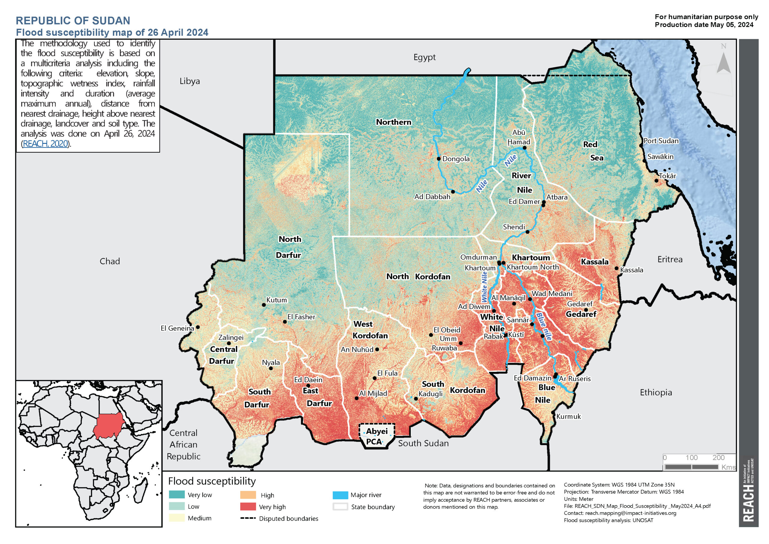
In April 2024, REACH produced a comprehensive flood susceptibility map for Sudan. This vital tool identifies regions most at risk of flooding, with areas marked in red and orange indicating high susceptibility. But why does this matter, and what does the map reveal? Let’s dive into the details.
Flood Risks
In recent years, Sudan has faced increasing challenges related to flooding. These floods have had devastating impacts on communities, infrastructure, and agriculture, particularly in regions with high susceptibility.
Seasonal Patterns and Predictability
During Sudan’s rainy season, typically from June to September, there is an expected increase in events of flooding across key locations in Sudan. This flooding most often occurs as a result of river overflow and flash floods compounded by inadequate drainage systems and can thus be predicted using different analytical approaches.
Vulnerable Regions
The eastern and southern regions of Sudan, including the Blue Nile and White Nile River basins are highlighted as being particularly prone to flooding due to their low-lying topography and flat terrain, which exacerbates the risk of rivers overflowing during heavy rainfall. Additionally, major cities in Khartoum, Wad Madani, and Kassala were also highlighted as being particularly prone to flooding, with Khartoum especially vulnerable due to its location at the Blue and White Nile confluence.
The flood susceptibility map for Sudan highlights several key areas at risk:
- High-Risk Areas: Regions marked in red and orange are particularly susceptible to flooding. These areas require immediate attention for disaster preparedness and mitigation efforts.
- Analysis Criteria: The map is based on a multifactorial analysis, incorporating various criteria that contribute to flood risk:
- Elevation: Lower areas are more prone to flooding.
- Slope: Steeper slopes can lead to faster runoff and higher flood risk.
- Topographic Wetness Index: Indicates areas likely to retain water.
- Rainfall Intensity and Duration: Areas with heavy and prolonged rainfall are at higher risk.
- Distance from Nearest Drainage: Proximity to rivers and streams increases flood susceptibility.
- Height Above Nearest Drainage: Lower height increases flood risk.
- Landcover: Vegetation can affect water absorption and runoff.
- Soil Type: Certain soils retain water better, reducing runoff and flood risk.
Impacts of Flooding on Communities
Floods can have severe consequences for communities, disrupting lives and livelihoods. Here are some of the major impacts identified in high-risk areas:
- Damage to Homes and Infrastructure: Floodwaters can destroy homes, roads, and bridges, leaving communities isolated and without essential services.
- Agricultural Losses: Flooding can wash away crops and livestock, leading to food shortages and economic hardship for farming communities.
- Health Risks: Floodwaters can contaminate drinking water sources, spreading waterborne diseases and increasing health risks for affected populations.
Humanitarian Aid and Disaster Preparedness
Understanding flood susceptibility is crucial for guiding humanitarian aid and disaster preparedness efforts. By knowing which areas are most vulnerable, we can better protect communities and allocate resources effectively.
Climate Change and Future Risks
Climate change is increasing the frequency and severity of extreme weather events, including floods. This makes tools like the flood susceptibility map even more critical:
- Increased Flood Risk: As climate patterns shift, regions that previously had moderate flood risk may now face higher susceptibility. The map helps identifying these changes and adapt strategies accordingly.
- Protecting Vulnerable Communities: Ensuring that communities are protected from the impacts of flooding is essential for saving lives and maintaining stability. By staying informed and prepared, we can mitigate the adverse effects of climate change.
Understanding flood susceptibility is crucial for guiding humanitarian aid, disaster preparedness, and implementing effective mitigation strategies. The latest flood susceptibility map for Sudan, produced by REACH, is a vital tool in these efforts.
Access the full map.
Visit our Resource Centre for more details on Sudan: Resource Centre | Impact (impact-initiatives.org)
21/12/2023 – Democratic Republic of Congo – Building an Environmental Country Profile for DRC to support ongoing and future humanitarian action
The Democratic Republic of Congo (DRC) remains one of the most complex and protracted humanitarian crises in the world. Due to conflict and natural disasters, it is characterised by five main humanitarian impacts: population movements, acute food insecurity, acute malnutrition, epidemics, and protection issues. IMPACT– through its initiative REACH – collaborated with the Global Shelter Cluster to develop an environmental country profile for DRC, with the aim of providing environment-related analysis that can support ongoing humanitarian operations. The profile also includes suggested actions to improve the environmental footprint and impact of shelter and settlements-related operations.
Indeed, much of the impact of a crisis and its response involves environmental factors. It is being increasingly understood that not considering the environment in humanitarian response can reduce its impact and lead to greater harm for those affected by a crisis.
At the same time, when responding to disasters and other crises, humanitarian organizations have limited time or means to collect, analyse, and integrate information on the environment into response plans and operations. This can happen even where considerable information is available from public sources, local organizations, and experts, and from previous responses. The classic approach has been to send in a team of experts to advise on environmental aspects of a response. However, this is only possible for major disasters, leaving a gap for small to medium events.
This DRC Shelter Environmental Country Profile uses a different approach: collecting, summarising and, where necessary, providing additional analysis of response-related environmental information before a crisis so that it is available to responders when needed. This ready-reference approach focuses more on creating a catalogue of what information is available than providing a detailed analytical report. It also includes suggested actions to improve the environmental footprint and impact of shelter and settlements-related operations. xx
The profile presents an array of information, including flood zone mapping, a shelter construction overview, environmental risk assessments, an overview of environmental organisations, maps of IDP camps versus protected areas, and more.
Moving forward, one key recommendation from the report is to strengthen the collaboration between REACH, the Shelter Cluster, and the Camp Coordination & Camp Management Cluster to develop more thorough GIS systems to monitor displacement camps and their impact on the environment.
30/11/2023 – Global – Exploring how MSNAs can support policy making on non-economic loss in the lead-up to COP28
IMPACT will be present at COP28 to share its growing work to inform climate action. To support the discussions, our new policy brief, published today, uses humanitarian research to strengthen the evidence base of international policymaking on non-economic losses (NELs) in fragile and conflict-affected situations.
What are non-economic losses (NELs)? While there is no exhaustive list of NELs, the United Nations Framework Convention on Climate Change (UNFCCC) defines them as “a broad range of losses that are not in financial terms and not commonly traded in markets. They may impact individuals (e.g. loss of life, health, mobility), society (e.g. loss of territory, cultural heritage, indigenous or local knowledge, societal or cultural identity) or the environment (e.g. loss of biodiversity, ecosystem services).”
This brief presents the findings from a joint research project conducted by IMPACT and the Secretariat of the Platform on Disaster Displacement (PDD). In exploring the interplay between displacement, disasters and climate change impacts, and NELs in fragile and conflict-affected situations, this paper underscores a crucial data gap. It advocates utilising humanitarian Multi-Sectoral Needs Assessments (MSNAs) to deepen our understanding and inform policy decisions in these complex environments. Widely used by humanitarian actors, yet under-leveraged in the global Loss and Damage (L&D) debate, MSNAs offer a robust framework for analysing various aspects of displacement and related NELs.
The brief focuses on a variety of non-economic losses suffered at the individual and household level, felt through impacts on well-being and access to basic services, by using findings from MSNAs in CAR, Somalia and Afghanistan. It raises the questions:
- What do people lose due to disasters, climate change, and their impacts, and how does displacement fit in people’s responses to Loss & Damage experience?
- What do people lose because they are displaced in the context of disasters and climate change impacts?
- What do people lose when they are affected by disasters during their displacement?
In addition to providing answers to these different questions, identifies several avenues for making MSNA data more actionable for global discussions and decisions on L&D, by providing evidence and perspectives on displacement and human mobility components, and in turn aims to support discussions on these topics at COP28. Some of these recommendations include:
- Align hazards included in MSNA indicators with global policy frameworks to ensure consistency and comparability across countries.
- Adopt specific, appropriate methods for accurately measuring exposure of populations to slow-onset disasters like drought and sea-level rise.
- Add NELs-focused data disaggregation criteria to allow for a more nuanced analysis.
- Complement MSNA data with secondary data highlighting linkages between conflict and climate change to broaden the scope of analysis to climate-related L&D suffered by populations affected and displaced by conflict.
- Triangulate MSNA data with qualitative insights from Area-Based Assessments for a more comprehensive and fine-grained understanding of impacts suffered by different individuals and groups.
- Integrate MSNA findings into national humanitarian assessments and planning processes, and international policy formulation, regarding loss and damage to fill existing data gaps.
20/11/2023 – Syria – Three Years into the Water Crisis in Northeast Syria: Main Gaps and Adaptation Efforts Going Ahead
Although water has traditionally been a scarce resource in Northeast Syria, the past three years have seen a deteriorating crisis with consequences for water, sanitation, and hygiene (WASH), as well as food and livelihoods security. The latest analysis from REACH provides an overview of the impacts of the water shortage on local communities.
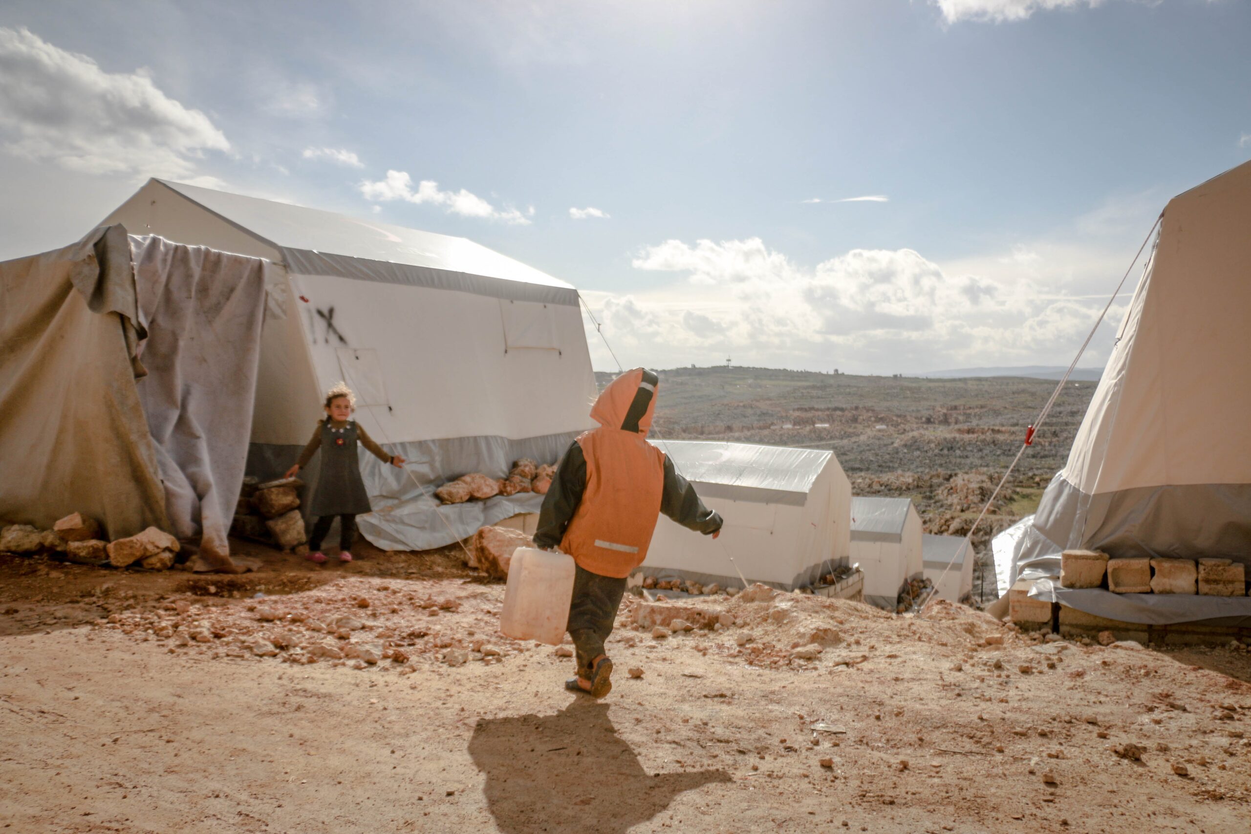
Drought and poor socio-economic conditions are severely affecting Northeast Syria’s population. Photo by Ahmed Akacha
Research points to a century-old drying trend in Northeast Syria related to climate change, which has likely further exacerbated the current water crisis. Climate adaptation should be strengthened through a coordinated response at all levels, from authorities to NGOs, private actors, and communities.
Twelve years into the conflict and ensuing humanitarian crisis, Syria also faces severe water shortages with knock-on effects on other needs and sectors. While water scarcity has historically impacted the region, research indicates the current crisis has likely further been compounded by drying conditions related to climate change.
Decreasing rainfall in the past three years appears to be among the immediate drivers of the crisis, contributing to 20-year record low groundwater levels and the lowest flows ever seen on the Euphrates River. Intensive water usage for agriculture has also contributed to reducing groundwater reserves and the quality of water.
Unequal access to water, public health risks and reliance on humanitarian support
Despite the worsening situation, people’s primary sources of water have remained generally the same throughout the crisis. This is most likely explained by the impact of humanitarian action, through measures ranging from water trucking to the retrofitting of water stations. It also suggests that emergency intervention is still crucial in facilitating communities’ access to water sources.
Larger communities – with at least 5,000 people – reported mainly relying on piped water networks, that generally provide access to more and safer water. Smaller communities – with less than 1,000 people – often depend on unregulated and expensive private trucking for drinking water, and on private boreholes for domestic use. Internally displaced people (IDPs) in informal sites also rely on private, or otherwise NGO-provided trucking, and have even reported drinking surface water, with significant associated health risks.
The lack of adequate sewage management also further increases the risk of contamination from untreated water. Where sewage systems exist, it is still very rare that any form of wastewater treatment is in place. The cholera outbreak in September 2022, with almost 22,000 suspected cases, highlights how vulnerable people in the region are to contracting diseases from unsafe water sources.
Unaffordable food and declining livelihoods
The drought has also severely impacted the local agricultural and food sectors, with lower yields being reported, increased production costs and more money spent on imported goods. This is doubly affecting populations, as it diminishes incomes for agricultural workers – almost a fifth of Northeast Syria’s employed population – and makes food overall unaffordable for consumers. Coping strategies such as skipping meals and prioritizing food for vulnerable household members have become more widespread.
Beyond agriculture, the drought has indirectly affected economic activity across all sectors through reductions in electric power generation and a practical failure of public electricity networks.
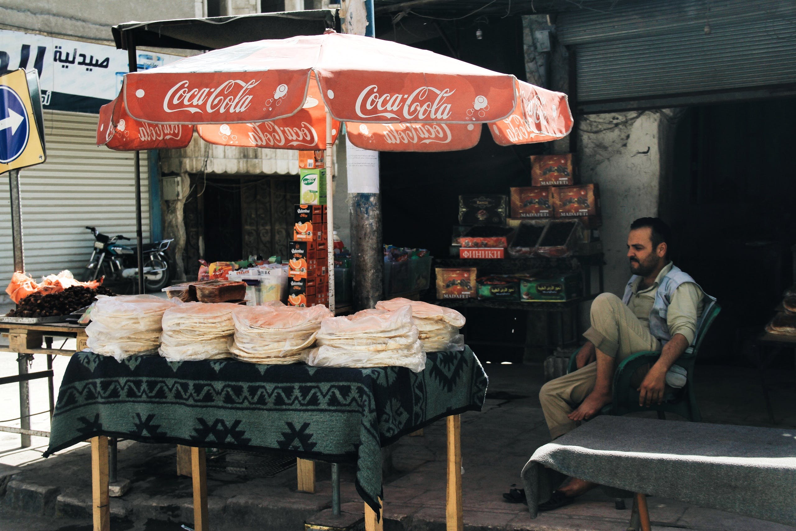
Food is largely unaffordable in Northeast Syria even as goods are available on the market. Photo by Sena N. Altay
Looking ahead: What the response says
Research points to climate change and particularly a long-running drying trend in the region as factors that could lead to more water crises in Northeast Syria occurring in the future. During three focus group discussions, REACH gathered insights from 24 NGO actors operating in Northeast Syria on how to respond to the current crisis and prepare for future extreme conditions.
Participants made clear that climate adaptation measures should be deployed in a coordinated manner among all relevant actors, from authorities to affected populations. Some of the main topics and priorities that came out of these discussions included: engaging populations on water-saving measures, strengthening cross-boundary cooperation between neighbouring countries with shared water resources, supporting agriculture in reducing water use by means of climate-smart agricultural projects (i.e. rainwater harvesting systems) or diversifying away from hydropower towards solar and other energy alternatives.
Read here our full brief and detailed situation overview to learn more about Northeast Syria’s water crisis.
13/11/2023 – Moldova – Exploring the Impact of Climate Change Hazards and Social Vulnerability in Central Moldova
Moldova has been experiencing a severe drought since 2021, and the economy of the country relies heavily on agriculture: nearly 74% of its territory is agricultural land, and 70% of the rural population identify agriculture as the primary source of their livelihoods. Agriculture is one of the sectors most affected by climate change, and can lead to issues with food security, sanitation, development of diseases, increased cost of living, and stress on energy sectors. Drought can increase the risk of wildfires, as well as potentially increase the severity of flooding.
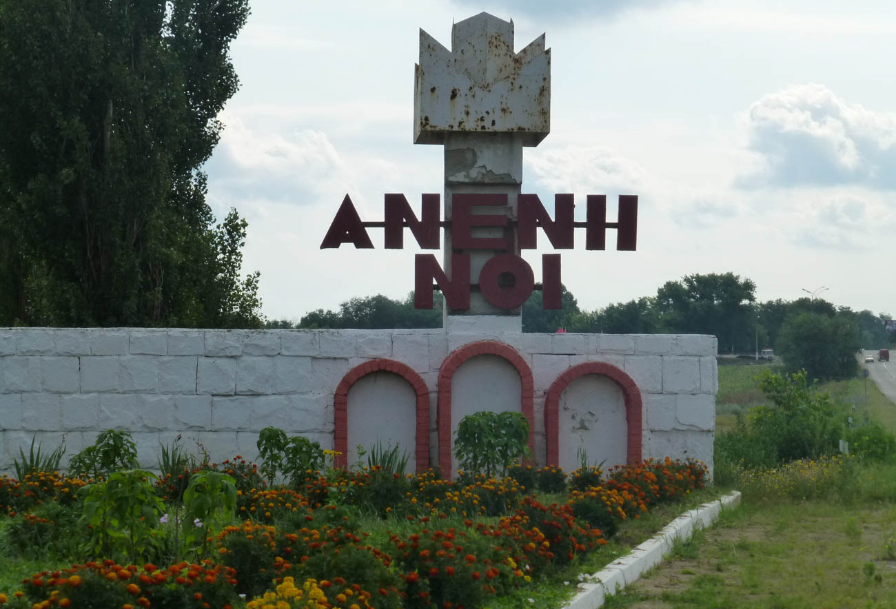
In order to understand these hazards and the population’s exposure to them, IMPACT has partnered with the STRIVE Consortium, made up of Acted, Libraries Without Borders, and REACH (an initiative of IMPACT and Acted), and funded by Agence Française de Développement (AFD), to perform an Area-Based Risk Assessment (ABRA). The ABRA used geospatial data such as satellite imagery and weather data to identify natural hazards and assessed four communities in Anenii Noi Raion for social vulnerability through in-person interviews. Key findings from this study highlight where hazards were found to be most severe and most likely to occur, as well as the capacity of communities to respond.
Arable land occupies 55% of the total area of the raion, and agriculture in the area is classed as “high risk” for an increased impact of agricultural pests, diseases and weeds, increased irrigation requirements, increased soil erosion, salinisation, desertification, and increased flood frequency and intensity. These risks are all related to climate change, and could potentially change both the landscape and yields of agriculture as well as exposure to natural hazards for the population.
Hazards included in the ABRA were wildfires, drought, heat and cold waves, climate change trends, floods, deforestation, soil erosion, and air pollution, as well as hazards such as earthquakes, severe weather events, landmines, and diseases and pandemics. Additionally, resources such as hydrography, wastewater and waste management in the Ţînțăreni landfill, gas and oil supply infrastructure, and the electricity network were contextualised for communities across the raion.
Four sample communities were then assessed for their social exposure, with the aim of understanding:
- Which hazards are most relevant to a given community?
- What coping tools does this community have?
- Where are vulnerable groups, such as families with children, persons with disabilities, and others?
- How close is the community to emergency services?
These factors of natural hazards, exposure, and coping capacity were applied at the community level to identify what natural hazards were effecting the community the most, who was most likely to be affected, and what public strategies were available to them for help and assistance.
From these analyses, the local government will be better able to plan Disaster Risk Reduction strategies that are targeted to specific communities, increasing their resilience and reducing the impact of natural hazards on the environment and agricultural activities. Findings from this report will also be used in conjunction with smallholder farmer trainings through Acted, strategising individual responses to protect livelihoods in the raion.
For a more comprehensive overview of findings from this assessment, visit Moldova’s page on the REACH Resource Centre and read the full Area-Based Risk Assessment: Anenii Noi Raion.
13/10/2023 – Global – International Day for Disaster Risk Reduction (DRR)
As the 13th of October marks the International Day for Disaster Risk Reduction (DRR), this year’s theme “Fighting inequality for a resilient future” serves as a reminder of the reciprocal relationship between disasters and inequality. To that end, IMPACT commits to informing disaster risks and resilience building activities for crisis-affected people around the world, in turn aiming to contribute to a more inclusive and resilient future. In this interview, Nataliia Makaruk, IMPACT’s Senior Climate & Disaster Assessment Officer, reflects on the state of DRR data and interventions globally.
Describe the work IMPACT is currently undertaking in the field of Disaster Risk Reduction (DRR) as of 2023? Are there any specific, noteworthy examples of our research published this year?
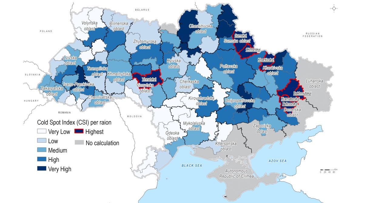
Cold Spot Index classes across Ukraine for winter season 2023/24
This year was one of the most fruitful in terms of climate and DRR research for IMPACT. As of October, IMPACT has produced around 40 research products, ranging from single hazard maps to comprehensive multi-hazard risk assessments. The biggest share of DRR research was conducted by our Ukraine country team (14), aiming to inform the community on natural and technological hazards and support them with disaster preparedness planning. Multi-hazard risk assessments have been conducted in Chernihivska, Odeska, Kyivska, Vinnytska region, Chernihiv City and Kryvyi Rih. Particular attention should be paid to the Cold Spot Risk Assessment, considering the upcoming winter and ongoing war in Ukraine.
Other countries where IMPACT has DRR research projects include Central Asia, Ethiopia, Moldova, , Libya, Niger, Sudan, South Sudan, Syria, Uganda, and Yemen.
How can data and analysis inform efforts to address climate change and disaster risk? Do you see any specific data gaps?
There are many DRR and climate risk indexes, and research exists at both global and national levels. However, the availability of reliable and relevant data for risk analysis is much less when we filter down to the local level. The most acute scarcity of data we find is for the vulnerability component of risk, particularly for coping and adaptive capacities of communities to withstand and recover from natural stressors. At best, this data is collected directly from local populations, who are the first responders and who bear the impacts of hazards. Here, IMPACT’s biggest advantage lies in its ability to conduct interviews with households in some of the most remote areas, gathering vital information regarding their exposure to and resulting impacts of disasters.
Where do you see IMPACT’s climate and DRR workstream heading, and are there specific research areas that can be expanded?
IMPACT is constantly exploring areas where data and evidence can make a difference in supporting local and national stakeholders in conflict-affected and fragile contexts. Among them are assessments on climate change adaptation and livelihood resilience practices, analysis on climate–induced displacement, analysis of ecosystem-based services, and usage of nature-based solutions for disaster risk mitigation. IMPACT is also exploring methodologies that promote and utilise the knowledge of indigenous people to shape more comprehensive and people-centred disaster risk reduction and climate change adaptation solutions.
Find out more about our DRR and climate work in our climate watch thread below.
13/09/2023 – Libya – Initial findings assessing the impact of Storm Daniel on Libya
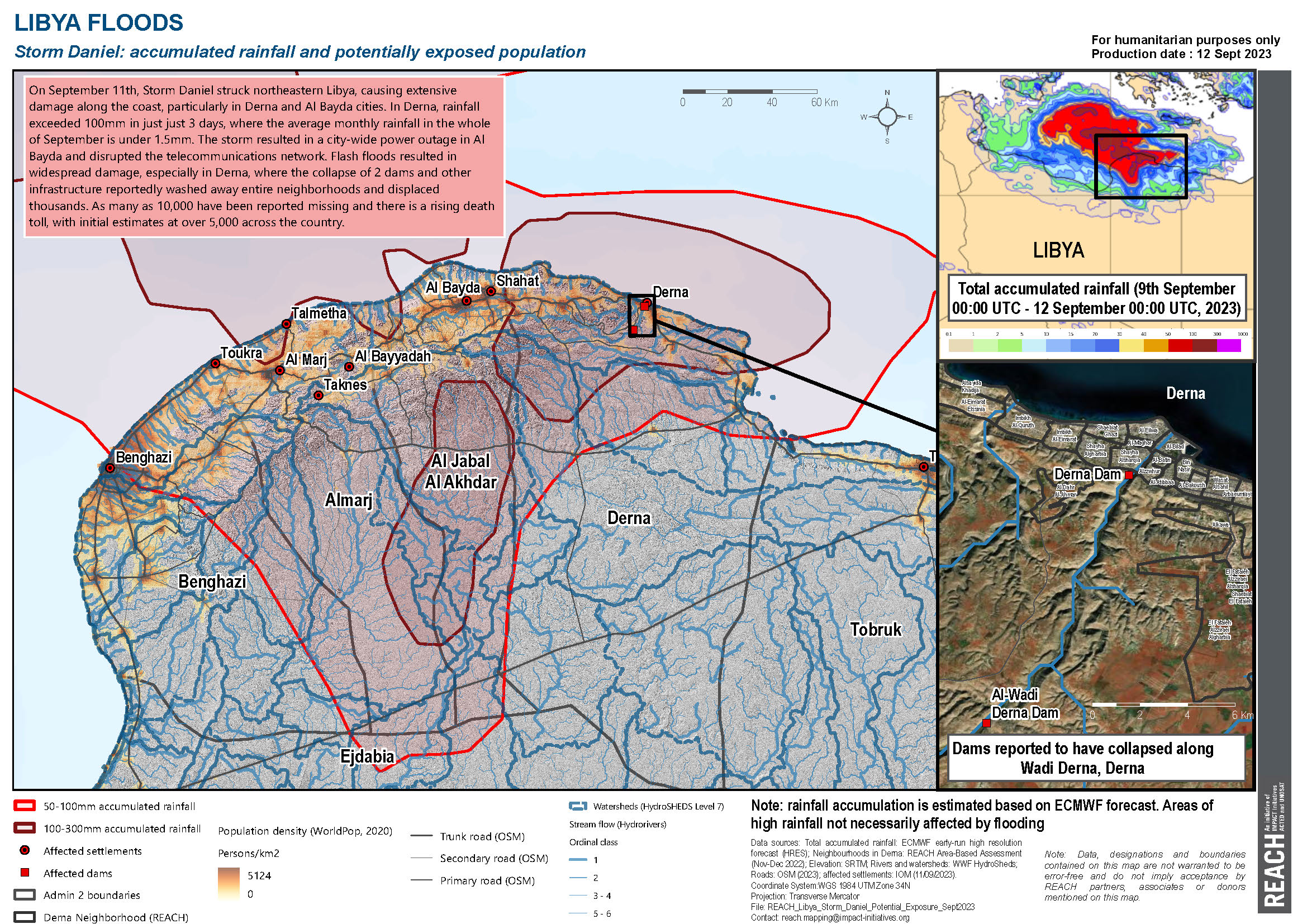 On September 11th, Storm Daniel struck northeastern Libya, causing extensive damage along the coast, particularly in Derna and Al Bayda cities. The storm resulted in a city-wide power outage in Al Bayda and disrupted the telecommunications network. In Derna, rainfall exceeded 100mm in just 3 days, where the average monthly rainfall in the whole of September is under 1.5mm. In tandem, flash floods resulted in widespread damage, with catastrophic effects in Derna, where the collapse of 2 dams and other infrastructure reportedly washed away entire neighbourhoods and displaced thousands. As many as 10,000 have been reported missing and there is a rising death toll, with initial estimates at over 5,000 across the country.
As the situation continues to unfold and information on the humanitarian impact remains scarce, IMPACT/REACH is mobilising an emergency response to provide decision-makers with a rapid analysis of conditions on the ground. REACH published an initial map that reveals the extent of the disaster.
The maps found areas most affected by the storm faced the highest accumulated rainfall. Although areas with very high rainfall do not necessarily indicate flooding, heavy rainfall along the streams within the mapped watersheds could have resulted in increased stream runoff, potentially leading to flooding in these regions. It’s important to note that many of these streams are wadis, which are typically dry.
Find out more on the extent of the disaster in REACHs first map: https://bit.ly/LYB_FloodsStormDaniel
Further Resources:
REACH also published a Settlement-based Assessment in Derna in March 2023 revealing findings on key services, livelihoods, social cohesion, as well as migration, prior to the storm. It showed pre-existing basic services gaps & pre-existing vulnerabilities such as:
- damaged infrastructures of healthcare centres in Derna centre, reportedly contributes to health workers’ reluctance to work in these facilities and the unavailability of sufficient and specialised staff there
- chronic occurrence rate of power cuts was confirmed in the Electricity FGD to be higher in the neighborhoods on the outskirts of Derna (Arbaeumiya and Alsayida Khadija) and in peri-urban areas neighbouring the city centre (El Fataieh).
- limited functional sewage network in the outskirts of the city centre and on peri-urban areas close to the city of Derna.
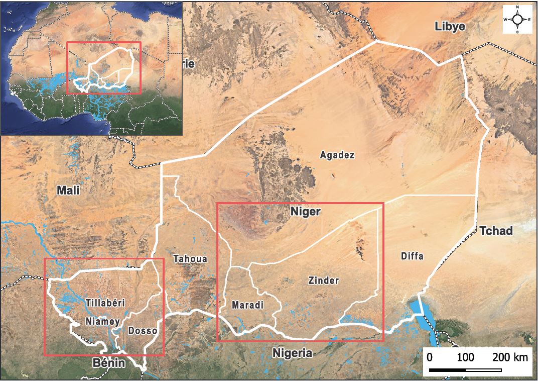
06/08/2023 – Niger – Flood susceptibility in Niger
 Flooding is one of the main climatic hazards in Niger, and in the last 30 years, both the frequency and impact of flooding events have increased. Indeed, as populations seek fertile soils and water available throughout the year, areas unfavourable to urban development face rapid and unsteady population growth, which combined with the modifications of the use of the soils led to stream increase across the country.
Consequently, the increase of floods, compounded by population growth, uncontrolled urban development and chronic insecurity in the Niger and Central Sahel region, pose further risks to people who are already vulnerable. An estimated 250,000 people were affected by floods in 2021, and this number rose to 327,000 in 2022. The resulting impact has included loss of life and waterborne diseases, damaged or destroyed property, and erosion of livelihoods.
To support aid actors in understanding which regions and population groups are most vulnerable, IMPACT produced a flood susceptibility analysis, aimed at complementing existing studies by identifying areas with the highest flood risk and where populations are most vulnerable. Integrating multiple factors from remote sensing and public satellite imagery, such as ground drainage, rainfall duration, land uses, and elevation, the analysis covers the regions of Tillabéri, Maradi, and Zinder, which were identified as those most severely affected by the recent floods of 2022.
Tillabéri Region
The analysis indicates that 42% of the population (1,533,920 people) is in the high susceptibility category, compared with 6,142 in the very high category. This “high susceptibility” category, despite containing close to half the population of the region, covers only 27% of the territory, reflecting the high population density in Tillabéri.
 Maradi Region
Localities in the Maradi region have very high levels of susceptibility to flooding, as 70% of the localities are close to waterways or in nearby valleys. Consequently, the total number of people falling in the “high-susceptibility” or “very high- susceptibility ” categories represents close to 60% of the total population in the region (around 2,721,043 people). The analysis indicates that the Southwest and the centre are the most at risk.
 Zinder Region
In the Zinder region, analysis shows that the localities in the South strip have a “high” or “very high” flood susceptibility, Dungass and Magaria being the most exposed, with 95% and 74% of their population, respectively, face high to very high flood susceptibility. Across the whole region, 44% (2,261,495 people) face high flood susceptibility and 2% (110,323) very high susceptibility.
As the analysis shows in these three regions, a high number of people are in high flood-risk areas. This situation risks worsening due to the persisting changes in land use and the diversity of the activities conducted, compounded with the predicted growth of the population by ten in 2050.
Therefore, if this study is necessary to estimate the susceptibility of flood occurrence, an in-depth assessment could be a next step to decide on preventive measures – for example implying infrastructure building.
Full report available here: https://bit.ly/45XiEOq
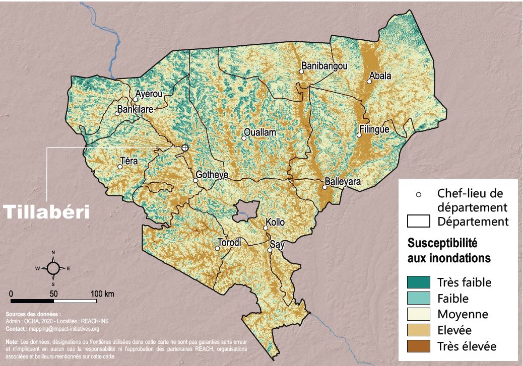
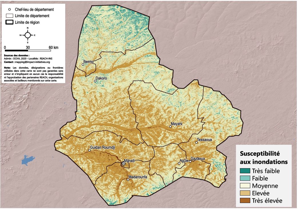
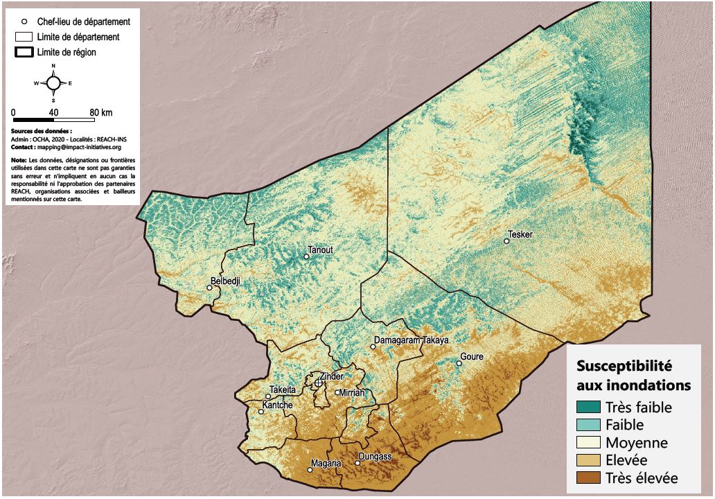
06/08/2023 – Niger – Susceptibilités d’inondation au Niger
Les inondations font partie des principaux aléas climatiques auxquels le Niger est exposé, et leur fréquence et intensité augmentent depuis plus de 30 ans. En effet, la recherche par les populations de terres fertiles et de sources d’eau disponibles tout au long de l’année cause une rapide croissance démographique non maitrisée dans les zones peu favorables au développement urbain. De plus, des précipitations extrêmes ainsi que d’importantes modifications d’utilisation et de la couverture des sols entrainent une augmentation du ruissellement des eaux de surface à travers l’ensemble du pays.
En conséquence, l’augmentation des inondations combinée à la croissance démographique, le développement urbain non maitrisé et l’insécurité chronique au Niger et la région centrale du Sahel sont des facteurs supplémentaires de risques pour ces populations déjà vulnérables. Alors qu’en 2021, environ 250,000 personnes avaient été affectées par des inondations, ce nombre est monté à 327,000 en 2022, résultant en des pertes en vie humaines, une augmentation des maladies d’origine hydrique, la destruction de biens privés et publics ainsi qu’à la dégradation des moyens de subsistance.
Afin de compléter les études existantes et aider les acteurs humanitaires à identifier les zones les plus exposées et où les populations sont les plus vulnérables aux inondation, IMPACT a conduit une analyse des risques au moyen de la télédétection et d’images satellitaires publiques intégrant de multiples facteurs physiques tels que le drainage et l’usage des sols, la durée des précipitations, ou le niveau des reliefs. Cette analyse a été conduite dans les régions de Tillabéri, Maradi et Zinder, identifiées comme les plus fortement affectées par les inondations de 2022.
Région de Tillabéri
L’analyse indique que 42% de la population (1,533,920 personnes) est dans la classe de susceptibilité élevée, contre 6,142 dans la catégorie très élevée. Bien que cette catégorie de « susceptibilité élevée » touche près de la moitié de la population de la région, elle ne couvre que 27% du territoire ce qui illustre une haute densité de population à Tallibéri.
Région de Maradi
Les localités de la région de Maradi présentent une très haute susceptibilité aux inondations, dans la mesure où 70% d’entre elles sont situées proches des cours d’eaux et dans la vallée de ceux-ci. Par conséquent, le nombre de personnes incluent dans les catégories de « susceptibilité élevée » ou « susceptibilité très élevée » représente près de 60% du total de la population dans la région (environ 2,721,043 personnes). L’analyse indique que les localités du Sud-Ouest et du centre sont les plus à risques.
Région de Zinder
Dans la région du Zinder, l’étude montre que la bande sud de la région présente une susceptibilité aux inondations « élevée » ou « très élevée » , Dungass et Magaria étant les localités les plus exposées avec respectivement 95% et 74% de leur population appartenant à l’une de ces deux catégories.
Au sein de l’ensemble de la région, 44% (2,261,495 personnes) sont dans la catégorie de la « haute susceptibilité aux inondations » contre 2% (110,323) dans la catégorie de la « très haute susceptibilité ».
Alors que l’analyse montre que dans ces trois régions, un nombre important de personnes est située dans des zones à haute susceptibilité d’inondations, cette situation risque de connaître une détérioration du fait de l’important changement dans l’utilisation des sols et de la diversification des activités effectuées, combinés aux prévisions allant dans le sens d’un facteur de croissance démographique de l’ordre de dix d’ici 2050.
Néanmoins, si cette étude est nécessaire pour estimer la susceptibilité de survenance d’inondations, des analyses approfondies seraient recommandées avant de décider de mesures préventives – impliquant par exemple la construction d’infrastructures.
Rapport complet disponible : https://bit.ly/45XiEOq
10/08/2023 – Syria – The Humanitarian Impacts of Northeast Syria’s Water Crisis
 Water has historically been scarce in Syria, yet remains available due to reliable sources such as the Euphrates River, groundwater, and higher rainfall levels at the northern border, supporting regions like Northeast Syria (NES). However, recent declines in these resources have raised concerns, such as record-low water levels in Euphrates dams, a 20-year low in groundwater reserves, and a three-year rainfall deficit.
Compounded by a decade of conflict, Syria faces challenges in addressing this water crisis and protecting itself against future dry periods. Building on the briefing note published in in 2022, REACH’s latest report examines the evolving drivers of the water crisis, their impact on households in Northeast Syria, and outlines what the humanitarian response can do to mitigate the effects of water crises and climate change. This report combines multiple sources including remote sensing data, secondary sources, and analysis from various REACH assessments, notably the Humanitarian Situation Overview of Syria (HSOS) which includes interviews with more than 4,775 KIs across 1,323 communities.
 Despite facing unprecedented lows in Euphrates and groundwater levels, the primary water sources in Northeast Syria have remained relatively stable throughout the water crisis, likely reflecting the impact of successful humanitarian interventions. While piped water has benefited larger communities by providing more access to safer water, in communities reliant on other water sources, only about a quarter of Key Informants (KIs) interviewed by REACH reported that households had sufficient water.
As seen with internally displaced persons (IDPs) in informal areas, KIs reported relying on private wells and boreholes for water needs but depended on water trucking by NGOs or private vendors specifically for drinking water, which is often more expensive and unregulated. Given the significant gaps in sewage management, treatment, and general WASH infrastructure, relying on untreated water sources poses a substantial risk of spreading waterborne diseases. This situation places Northeast Syria at risk of a potential second cholera outbreak during the current summer months.
 The water scarcity crisis has implications beyond domestic supply, leading to reduced irrigation access and significant agricultural shortfalls. Consequently, although food remains available, it is often unaffordable, pushing households to opt for lower-quality foods and, in more dire cases, reducing meal portions. High food prices need to be understood in the context of the weak livelihood situation, especially for the nearly one-fifth of the working-age population employed in agriculture, who have been affected by production losses.
Beyond agriculture, all sectors are affected by the reduction in electricity generated through hydroelectric dams on the Euphrates. Hydropower serves as the primary source of network electricity. This is highlighted by reports from KIs in two-thirds of assessed locations, where people reported six or fewer hours of electricity access per day.
Marked by severe drought and declining water levels in the Euphrates River, it is clear the ongoing water crisis is part of a long-term drying trend in Syria. While efforts to mitigate humanitarian impacts are underway, such as adjusting water stations and promoting water-saving projects in agriculture, sustainable action at all levels will be necessary to adapt to the changing climate. Given the global successes already achieved with climate adaptation projects, it stands to reason that Syria, too, can adapt to climate change.
Read the full report: https://bit.ly/NESyria_WaterCrisis
See our previous coverage on the NES water crisis: https://bit.ly/SYR_WaterCrisisBrief2022
18/07/2023 – Nature-based Solutions – Bridging the gap between environmental protection and humanitarian action
21/06/2023 – The environmental impact of Ukraine’s prolonged conflict – Kakhovka dam breach
As Ukraine marks 16 months since the start of the conflict, it is clear that the impacts of the war go beyond a profound humanitarian crisis and include significant environmental consequences. At this week’s Ukraine Recovery Conference, held jointly by the UK and Ukraine governments, it will be important to consider environmental damage and ongoing hazards as a result of this crisis, as part of the discussions around stabilisation, recovery, and reconstruction planning.
Most recently the breach of the Kakhovka dam on June 6th – which resulted in the flooding of at least 80 settlements and a reported 50,000 hectares of forests – has raised serious concerns regarding the contamination of both surface and groundwater, from the flooding of facilities such as sewage collection sites, cemeteries, and landfills.
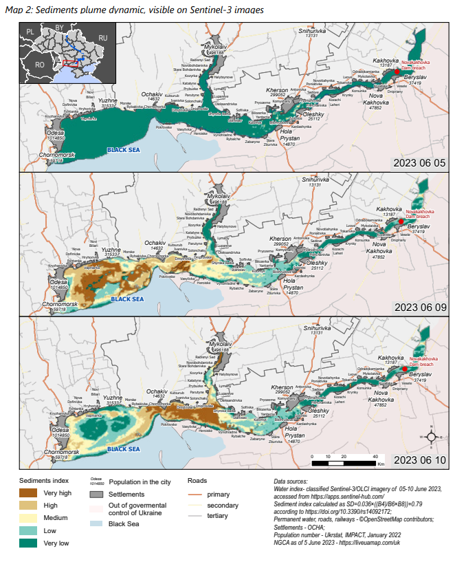 Particularly concerning is the 465,000 tons of transformer oil from the Kakhovka Hydroelectric Power Plant (HPP), which key informants reported to have contaminated water sources, altering the physical, chemical, and biological properties of aquatic ecosystems and natural habitats. The effects of oil contamination also extend beyond water bodies, as the oil-coated sedimentation on the soil can hinder the growth of vegetation, particularly soil algae. The suppression of vegetation has long-term implications for microorganisms that rely on these plants, leading to widespread mortality of these microorganisms in severely contaminated areas – posing risks to future fertility of the soil.
Rapid analysis based on REACH’s Hazardous Events Monitoring Initiative (HEMI) also identified up to 24 hazardous industrial facilities affected by the flooding that are of particular concern, with many having already been exposed to conflict or directedly damaged. These facilities contain a variety of hazardous substances each with its own environmental and health risk profiles.
While the immediate impacts on the environment are clear, longer-term consequences may take more time to reveal themselves, with far-reaching implications for crisis-affected people, their health, and their livelihoods. Find out more in our Kakhovka Dam breach Situation Overview
Further reading:
Kakhovska dam – Emergency brief
Kakhovska dam damage and flood event monitoring – June 6, June 7
Ecodozor – Interactive dashboard of environmental consequences and risks of fighting in Ukraine, supported by REACH data
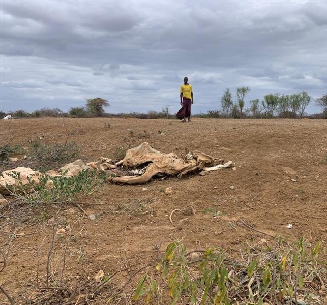
01/03/2023 – Horn of Africa | Understanding the far-reaching impacts of drought in Kenya, Somalia and Ethiopia.
T he Horn of Africa is facing its longest and most severe drought in recent history. The impacts of five consecutive failed rainy seasons and increasing rainfall variability have had a pronounced impact on rainfall-dependent livelihoods and increased challenges in accessing food and water.
With much of the assessed region characterized by pastoralist and agropastoral livelihoods, dry spells, occurring at critical cultivation stages, can have devastating impacts on crop health and growth. Meanwhile, for pastoralists, rainfall deficits often lead to lower water availability and may result in poor pasture health for cattle, as well as atypical migratory movements.
Using a combination of remote sensing and primary data, REACH published a report assessing drought trends and impacts across Somalia, Ethiopia, and Kenya. It also outlines results from two recent assessments in north-western Kenya and hard-to-reach areas of Somalia, investigating the impacts of drought on the humanitarian needs of affected communities.
Key findings:
- Research suggests the 2022 long rains were the worst-performing rains in over 70 years, with all assessed regions reporting below-average rainfall in 2022.
- Climatic data suggests rainfall variability is increasing across the Horn of Africa. As a result, the frequency of both droughts, as well as heavy rainfall and flooding, is likely to increase in the future. The region is already experiencing these effects, as much of the region has now experienced five consecutive failed rainy seasons, and rainfall for the upcoming 2023 long rains is also expected to be below average.
Kenya zoom-in: Turkana and Marsabit
Zooming into Kenya, where conditions are most concerning in Marsabit and Turkana Counties. Following four consecutive failed rainy seasons, both counties are expected to remain in IPC Phase 4 (Emergency) levels of food insecurity until May 2023 due to lack of food availability.
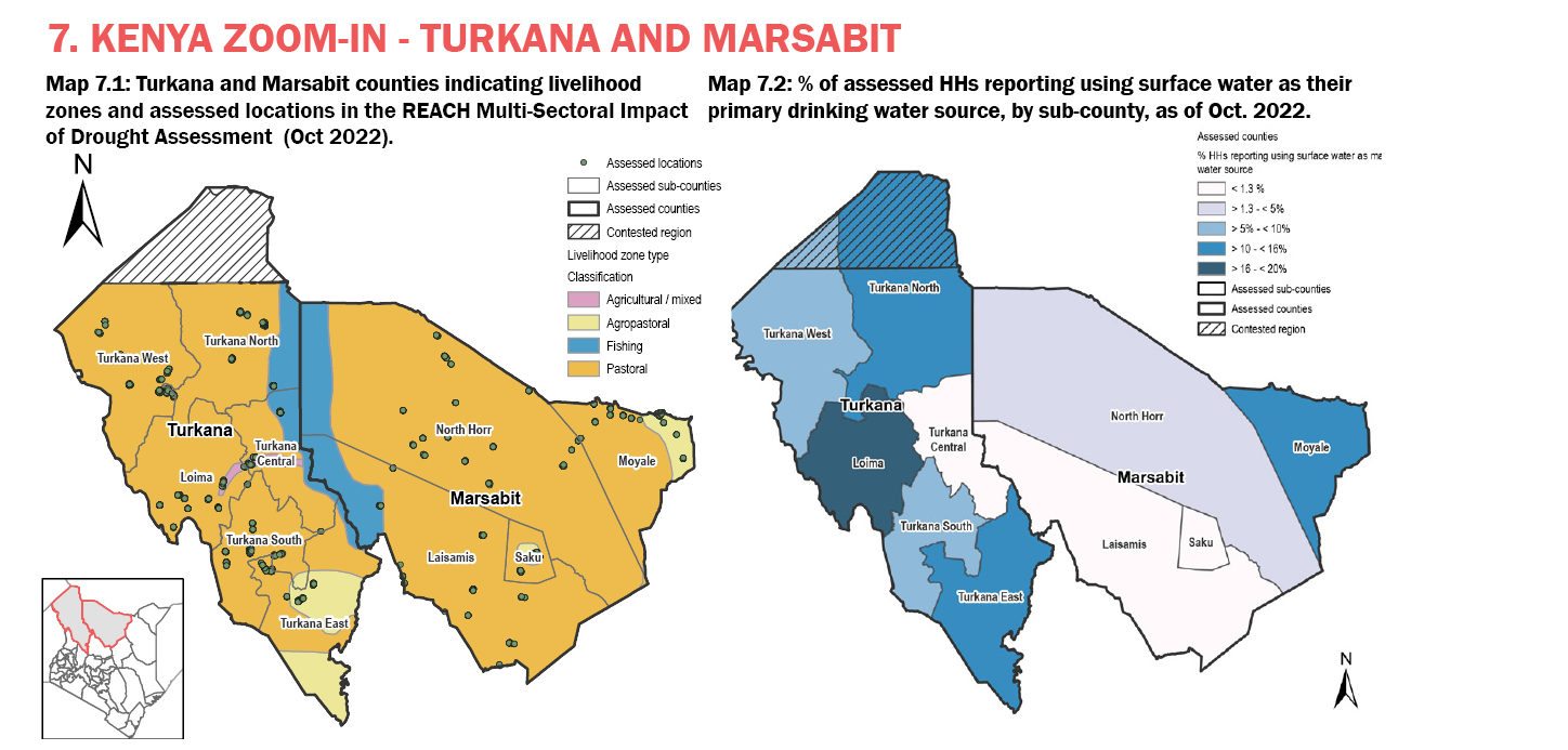
- Findings from the REACH Multi-Sector Drought Assessment, conducted in October 2022, found the majority (97%) of households in Turkana and Marsabit reported drought as a main challenge in the 6 months prior to data collection.
- While reduced access to sufficient food and loss of livestock were the most reported drought-related challenges, over half of the assessed households claimed to have received no assistance in response to the drought, with less assistance reported to be received overall in Marsabit county.
- As a result of these drought-related challenges, interviewed households reported considerable changes to primary income sources since 2019. This was particularly reflected in livestock-related livelihoods, due to livestock death (29%), lack of pasture (23%), as well as crop cultivation.
Somalia zoom-in:
Zooming into Somalia, where populations are facing elevated levels of acute malnutrition and population mortality. The impact of the prolonged drought has exacerbated water, sanitation and public health needs.
- The drought has had widespread impacts on both livelihoods and increased challenges to accessing food and water. Notably, surface water, which 43% of key informants reported as their primary drinking water source, is particularly vulnerable to droughts.
- Findings also point to the impact of the drought on livelihoods. Nearly all key informants from assessed agropastoral/agricultural settlements reported that the most recent 2022 Gu harvest was much lower for most people compared to the previous years’ Gu harvest.
Read the full report: Drought in the Horn of Africa – Regional Analysis
30/11/22 – South Sudan | Risk and resilience in five counties facing climatic hazards
South Sudan has faced intensifying dry and wet seasons for the past several years, with drought-like conditions followed by severe flooding that exceeded seasonal norms. Recurrent flooding has led to widespread displacement – over one million people in 2020 – destruction of livelihoods, worsening food security, and contamination of water sources, compounding existing insecurity in many regions of the country.
Whilst seasonal flooding is common across the areas in question, flooding has been more widespread in recent years, with greater impacts on crisis-affected people and their communities. More extensive flooding in wetland zones along the White Nile and Bahr al Ghazal rivers has partly been driven by higher flows upstream on the Victoria Nile in Uganda.
Our team in South Sudan has been monitoring cyclical drought and flooding patterns for several years, using remote sensing analysis to complement primary data collected through interviews and focus group discussions with people directly impacted by climatic shocks in these areas. Most recently, the REACH South Sudan team has produced in-depth profiles for five key counties at risk of climatic hazards in Jonglei, Upper Nile and Unity states, in partnership with the Global Facility for Disaster Risk Reduction and Recovery (GFDRR).
The profiles provide an overview of the socioeconomics of the counties, as well as environmental factors, climatic conditions and hazards, and infrastructure. An overview of the impacts of climatic hazards and other shocks such as conflict on population movement, market trends and urban change is also provided. The profiles aim to support decision makers in humanitarian response and disaster risk reduction programming in these areas:
Key findings
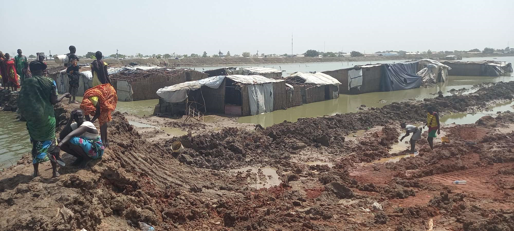
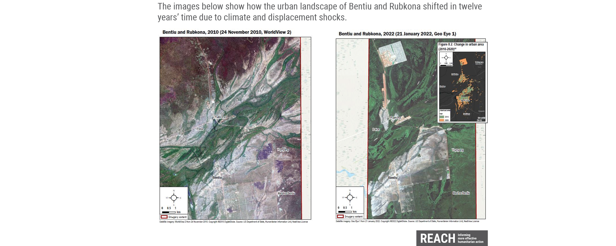
Major urban centres in some assessed counties have experienced extensive structural change in the past decade as a result of conflict and flood-induced population movement. This is particularly the case in Bentiu (Rubkona county) and New / Old Fangak (Fangak county).
Availability and functionality of community infrastructure varies across assessed counties, with some key settlements, in Pibor County in particular, located very long distances from a health centre. Findings suggest that shelters and key infrastructure experienced significant damage due to the 2021 flooding in all counties, whilst conflict-related damage was also evident in Old / New Fangak (Fangak County) and Bentiu (Rubkona County).
Episodic dry spells and drought-like conditions occur in all assessed counties, usually driven by short-term rainfall deficiencies and irregular rainfall patterns.
Observed and projected rises in temperature and precipitation trends due to climate change across all counties are likely to result in more frequent and extreme flooding and drought events in future.
Read the full county risk profiles: South Sudan | REACH Resource Centre
25/10/22 – South Sudan – Repeated climate shocks and irregular weather patterns have eroded the resilience of communities in Greater Kapoeta.
Throughout 2021, satellite data captured below-average rainfall and drought-like conditions in Kapoeta East and North, indicating risks to harvests and livestock. Field reports and prior REACH data also indicated high levels of food insecurity, likely caused by these climatic factors. In January 2022, media and field reports highlighted a large movement of people from Kapoeta East County to Kapoeta North, due to lack of food and water.
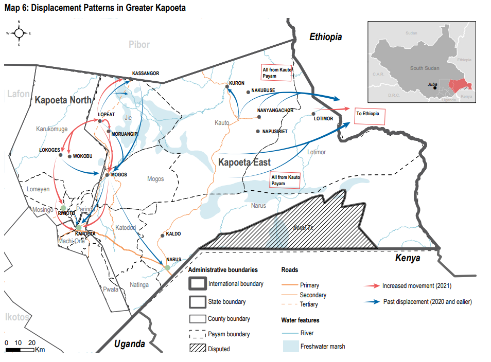
In response to information gaps about the food security situation, water access, and movement patterns, REACH conducted focus group discussions, interviews, and infrastructure mapping to understand the impacts of recent climate shocks, as well as coping strategies and barriers. The study found:
- At the time of the assessment, Greater Kapoeta had been experiencing drought conditions for several months. In addition, the area had also experienced flooding and heavy rainfall, locust infestations, crop disease, and other climate-related shocks in recent years.
- Due to limited and erratic rainfall patterns in 2021, existing water access issues were exacerbated, with some people reported to be regularly walking up to six hours to reach water points. Safe water sources were also unavailable, resulting in unclean water being shared by both humans and livestock.
- Drought conditions had impacted agro-pastoral livelihoods and food security. Discussion participants reported increased reliance on foraging for wild foods as a means of coping with poor harvests. Inadequate access to food and clean water was also noted as contributing to illness, whilst healthcare services remained limited.
- In many communities, repeated climatic shocks had reduced the ability to use prior coping strategies, like use of livestock for sale or slaughter, or access to humanitarian aid – leading to large-scale movement in response to the 2021-22 drought. These movement patterns became circular in subsequent months, as people moved to and from their places of origin in search of food and humanitarian aid.
Read the full report: Kapoeta_Climate_Assessment_Report_Final.pdf
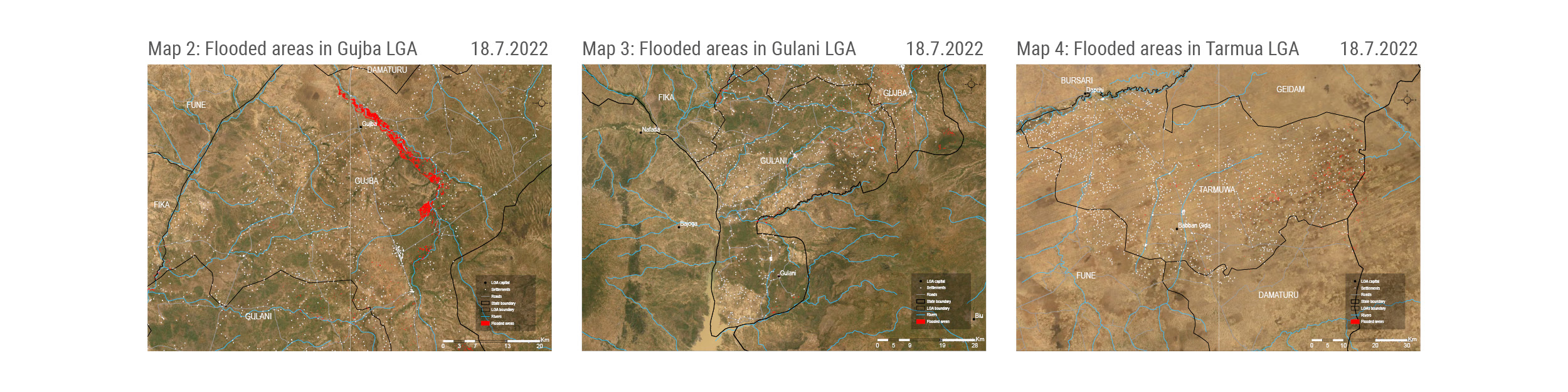
17/10/22 – Nigeria – The impact of Yobe floods on displacement and humanitarian needs.
Flash floods triggered by heavy rainfall in northeast Nigeria have caused deaths, injuries, and damage to homes and agricultural lands, leading hundreds of households to displace.
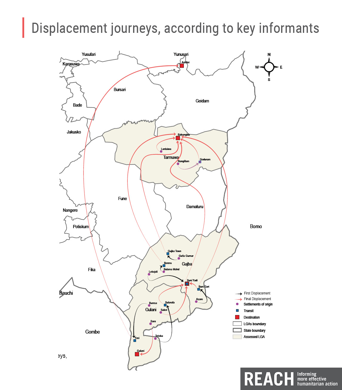
In recent years, flood frequency in the Borno, Adamawa, and Yobe (BAY) states has increased, often leading to displacement, destruction of basic service infrastructure, and increased risk of illnesses like malaria and other waterborne ailments. Climate and ecosystem changes, including rainfall variability, desertification, overgrazing, and overcultivation, have created a precarious situation where food scarcity and access to livelihoods have become intertwined with weather and environmental effects.
REACH conducted a rapid assessment in Yobe state in July, following a week of heavy rainfall and subsequent flooding. Through interviews and participatory mapping exercises with people who had displaced from the most flood-affected areas, our teams found that:
- Flooding had caused destruction to shelters, farmland, livelihood assets, and other household resources. Access to some communities was entirely cut off due to damaged roads, bridges, and communication lines.
- Hundreds of households were reportedly displaced – in some cases entire communities. Both displaced people and those who remained in flood-affected areas had a primary need for food, shelter, and core items like clothing, mosquito nets, and blankets. Due to destruction of food stocks and farmland, some people had resorted to foraging and eating wild foods.
- Interviewees reported that no aid had been provided to people remaining in flood areas at that stage. Those who had displaced were receiving shelter, food, and access to services from their host communities, but similarly, no support from designated aid actors had been reported.
Read the full Yobe Floods: Displacement and Humanitarian Needs Brief
26/09/22 – Iraq – Climate motivated displacement in search of new income-generation opportunities.
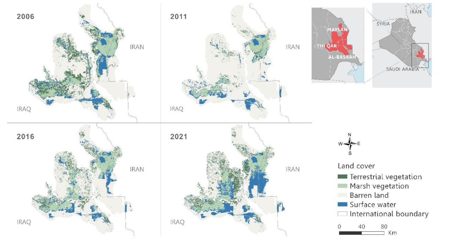
Map: Change in surface water level and vegetation in the marshlands every five years from 2006-2021
In southern Iraq, people who have historically been dependent on the marshlands for their livelihoods have been forced to leave in search of new income-generation opportunities.
The marshlands of southern Iraq account for just under half of the country’s inland waters and have historically been a critical livelihood source for households in Al-Basra, Maysan, and Thi Qar Governorates. In the early 1990s, Saddam Hussein drained the once-thriving marshes when Shiite rebels sought refuge there, causing almost 500,000 residents to flee. By the early 2000s, less than 10% of the original marshland area was still functioning. Despite efforts to restore the marshes in subsequent years, the area is once again at risk of reduced water levels.
Earlier this year, REACH conducted focus group discussions and interviews with people from affected communities, to understand how these climatic factors impacted livelihoods and influenced movement decisions. Some key takeaways:
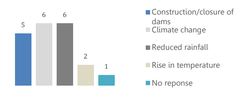
Graph: Frequently reported reasons for decreased water levels in the marshlands in Mejar Al-Kabir, Al-Qurna, and Al-Chibayish (from 8 KIs interviewed)
- Climate change effects such as reduced rainfall and high temperatures, along with the construction of dams in Turkey and Iran, were key reasons behind the reduced water levels and increased salinity of the marshes.
- The biggest adverse impact has been felt by people who rely on the marshes for income from fishing, agriculture, livestock rearing, handicraft production, and shelter construction. Diminished incomes have limited their ability to purchase food and other necessities, as well as ensure education for their children. Relocation, including to urban centres like Basra city, has been a key coping mechanism for marshland residents in need of new livelihood opportunities.

- Displaced discussion participants noted that improved access to water and living conditions were necessary before they could consider moving back. To prevent further displacement, participants noted a need for fertilisers for farming, fodder for buffalo rearing, improved transportation, and easier access to loans.
Read the full Iraq Climate Motivated Displacement: Baseline Report.
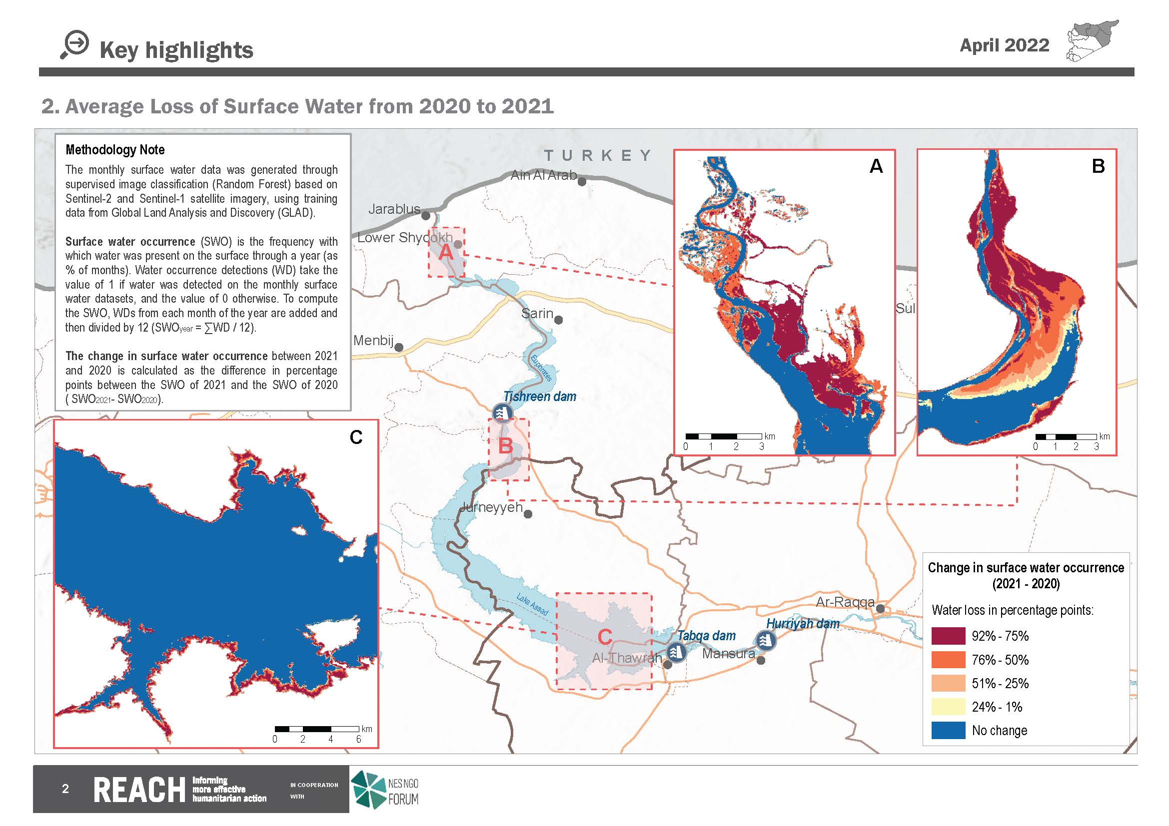
25/05/22 – Syria and Iraq – Remote sensing and ground-truthing for a more impactful water scarcity response in Syria and Iraq
Syria and Iraq are facing a water crises, with low rainfall, reduced water-streams (upstream dams, downstream salinization) and poor water management. To provide information on the scope and scale of water scarcity and worsening WASH needs, IMPACT Initiatives, via it’s inter-agency REACH, uses remote sensing (RS) with on-the-ground assessments to inform the humanitarian response, whilst also providing strategic information to support long-term planning for the worsening regional water crisis.
In Syria, through very high spatial resolution NDVI, cropland area, and surface water area data (available in a WebApp) REACH extracts detailed information on crop health/cropland abandonment, and monitors surface water area of reservoirs for a comprehensive understanding of water availability and use. Remote sensing derived information is used to target rapid need assessments, and is combined with in-depth multi-sectoral quantitative household surveys to enable response prioritization. These include water management area-based assessments, which provide area-level data on water infrastructure and management, to enable tailored and sustainable WASH interventions.
Learn more by checking out the briefing note – Humanitarian Impact of Water Shortages in Northeast Syria.
In Iraq, REACH fills critical WASH information gaps through extensive and multi-faceted remote sensing exercises, including surface water dynamics, and precipitation trends. REACH partnered with the WASH Cluster to visualize and analyse data on precipitation and temperature change, based entirely on open source data. Maps were developed which overlay precipitation deficit data with data on population density and vulnerable population groups (IDPs, returnees).
More info in the Precipitation and Temperature Change in Iraq – November 2021 brief.
In both contexts, this combination of remote sensing and assessment data is leveraged for a more impactful response.
13/04/22 – Somalia’s drought triggers new displacements
Somalia is experiencing the third drought episode in a decade, following three consecutive failed rainy seasons. The drought is compounding existing food insecurity among both pastoral and farming populations, and needs are spiking across the region – 13 million people are currently estimated to be facing high levels of food insecurity and water shortages. Our latest hard-to-reach assessment sheds further light on drought-affected areas specifically in the south and central districts of Somalia.
The drought was cited as the primary reason why most people most moved out of 87% of assessed communities, as new displacement was most commonly motivated by a search for food and water. Most people were reportedly skipping two or more meals a day in over half of the assessed locations (58%), while nearly half (45%) of the assessed settlements reported rivers or ponds as the main source of drinking water.
Additionally, the chronic insecurity in Somalia has obstructed the access to humanitarian assistance, while limiting the availability of basic public services such as the provision of healthcare and education. REACH found that in 97% of assessed locations, no NGO support had reportedly been provided in the three months preceding data collection.
Findings depict a grave situation. People residing in the assessed settlements were reportedly experiencing severe needs and had limited options for coping if conditions continued to deteriorate – posing a heightened risk of excess mortality.
Read the full report: REACH_SOM_Drought Response_Advocacy Brief
[metaslider id=”54755″]
20/04/22 – Syria – Understanding the humanitarian impact of the water shortages in Northeast Syria
While water access improved in recent months, due to the onset of the rainy season and increased flow in the Euphrates, groundwater levels have declined, and rainfall levels have remained substantially below long-term average levels in the current agricultural season.
REACH is providing an update through a briefing note on the humanitarian situation in light of the continued water crisis and reviews the impact on water access, electricity access, livelihoods, food security, and health. Various REACH sources, secondary sources, and information from REACH’s field team are used in this briefing note. This includes a Rapid Needs Assessment (RNA), conducted in March 2022, reviewing the agricultural and livestock situation in Al-Hasakeh governorate.
Key Takeaways
- Water Shortages : KIs reported that 21% of households in their community had insufficient access to water in August 2021. As the water network became less reliable, households reportedly relied more on private boreholes or wells, and water trucking. Yet, the high cost of water trucking was the most cited barrier to water access, reported by KIs in up to 46% of communities. These costs meant that households had to spend money on water at the cost of other necessities. Water access improved after August 2021 due to the onset of the rainy season and increased flow in the Euphrates. However, as drought conditions continued and groundwater levels have declined substantially, the situation is likely to worsen during the summer 2022.
- Electricity Impact : In January 2021, KIs in 50% of assessed communities reported having 9 or more hours of electricity per day in their community – by December, this had reduced to 19%. Levels have remained low into March 2022 despite rising water levels in the Euphrates because rationing has continued. Households are unable to cope with network shortages as the alternatives, solar and fuel-powered generators, are beyond the purchasing power of most.
- Livelihoods Impact : KIs in Hasakeh Governorate reported severe decreases in livestock numbers in March 2022. Sheep were most strongly affected, with 67% of KIs reporting herd sizes in their subdistrict decreasing by over 25%. Correspondingly, farmers have reportedly been giving up on livestock farming while crop cultivation and agricultural wage labour were similarly reported to be decreasing.
- Food Security Impact : Households struggle with the high cost of foods paired with low purchasing power; in March 2022, KIs in 82% of communities reported that households were unable to afford essential food items. Low wheat harvests in 2021 due to the drought have strongly contributed to this. With low rainfall continuing into the current agricultural season and considering the global surge in food prices, it is likely that this situation will worsen over the course of 2022.
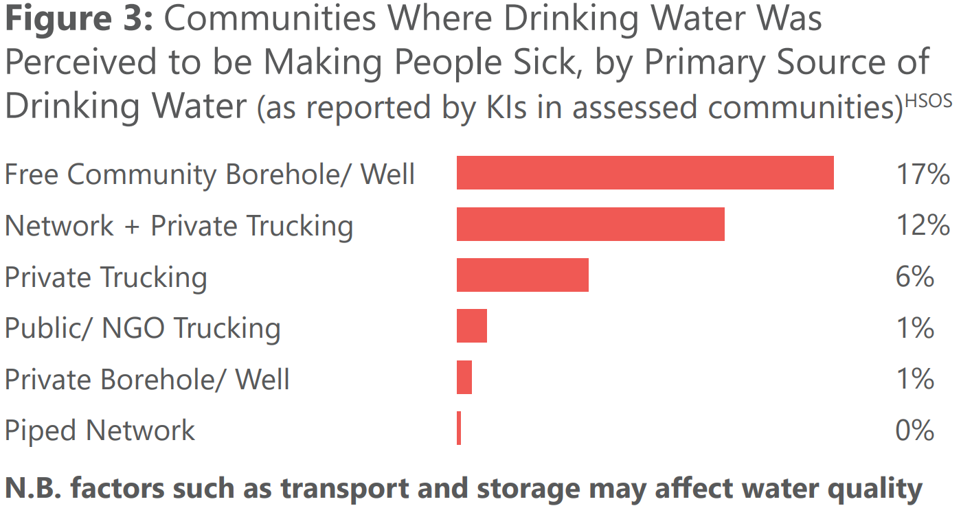
- Health Impact : Reduced water access led households to restrict their hygiene practices, which may make them more vulnerable to infectious diseases and skin diseases. Furthermore, the use of untreated water from boreholes, wells and water trucks increases the risk of waterborne diseases. In August, KIs in 19% of all assessed communities reported that drinking water was perceived to be making people sick – at 32%, this was even higher in communities that primarily relied on private water trucking for drinking water.
Learn more by checking out the briefing note – Humanitarian Impact of Water Shortages in Northeast Syria.
23/12 – IRAQ – Precipitation & Temperature Change analysed to provide a comprehensive understanding of anticipated climate-related challenges affecting Iraq
Iraq is expected to face an increasing water crisis, as climate change impacts such as a decrease in surface water levels and droughts are becoming more pronounced. The 2021 drought led the government to decide that only half of the available irrigated land can be used for the cultivation of winter crops, resulting in food security and livelihoods concerns. Contributing factors affecting a potential water crisis include the cutbacks in river flows coming into Iraq from neighbouring countries, as well as poor water management.
Changes in temperature and precipitation are key indicators of climate change and have a direct impact on droughts and access to water. REACH Initiative in partnership with WASH Cluster in Iraq conducted an indicative analysis of precipitation and temperature change to support emergency preparedness and planning, as well as to evaluate climate-related impacts on the population. The analysis traces the changes in precipitation and temperature and overlays this data with residence data of four population groups: returnees, internally displaced persons (IDPs), IDPs in informal sites, and the general population of Iraq (see Figure 1).
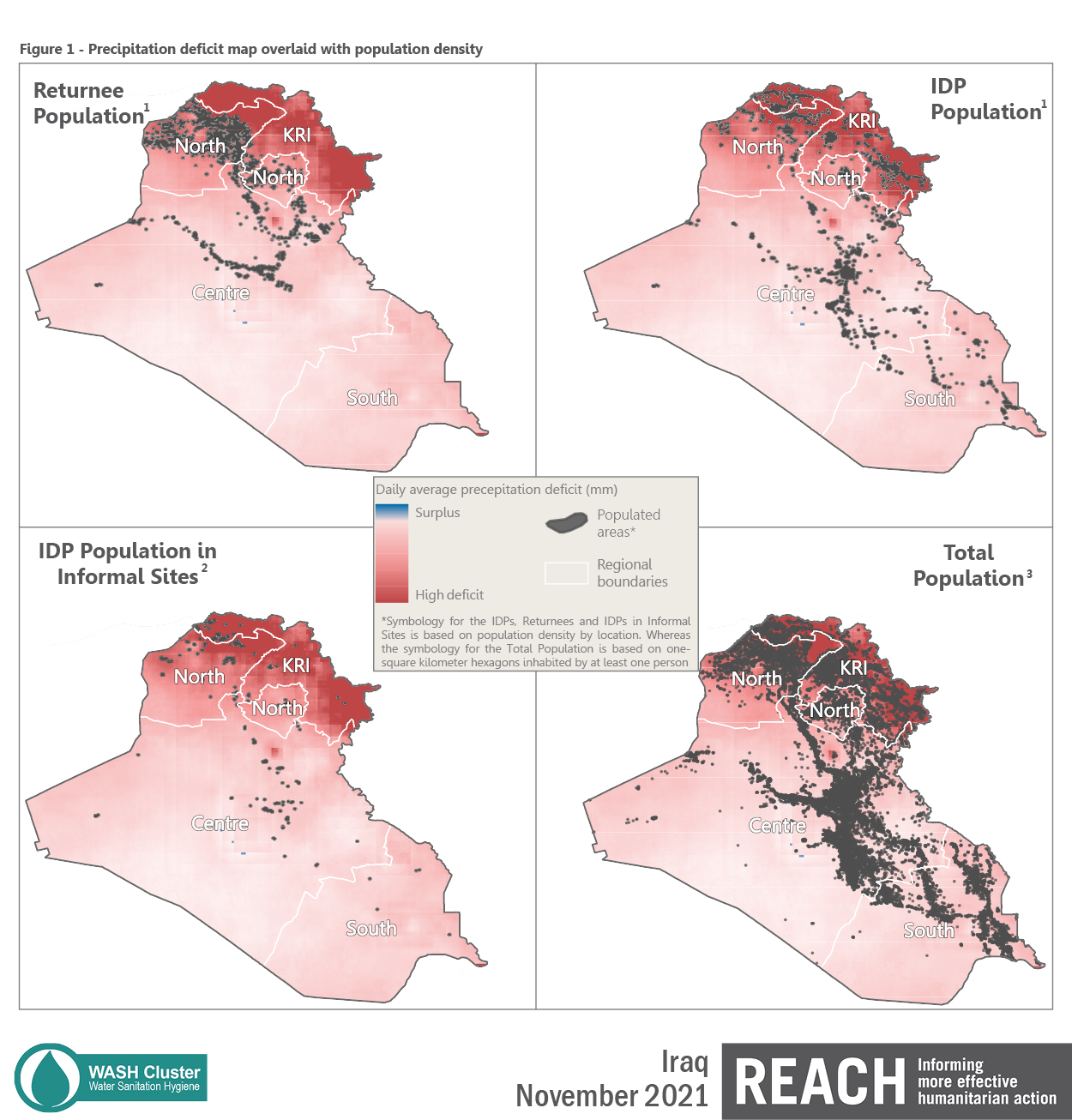
The analysis of precipitation (1981-2021 time period) and temperature (2015-2021 time period) change in Iraq suggests that:
- The highest precipitation deficit is prevalent in the northern part of Iraq, concentrated in Erbil, Duhok, Al-Sulaymaniyah and Ninewa governorates.
- IDPs (including those living in informal sites) and returnees are more likely to be affected by temperature and precipitation changes. Namely, almost three quarters (74%) of IDPs, 51% of IDPs in informal sites, and 44% of returnees live in high deficit zones.
- Monthly average temperatures of 2021 were higher in most months compared to both the 2015-2020 average temperature and the 2020 average temperature (see Figure 2).
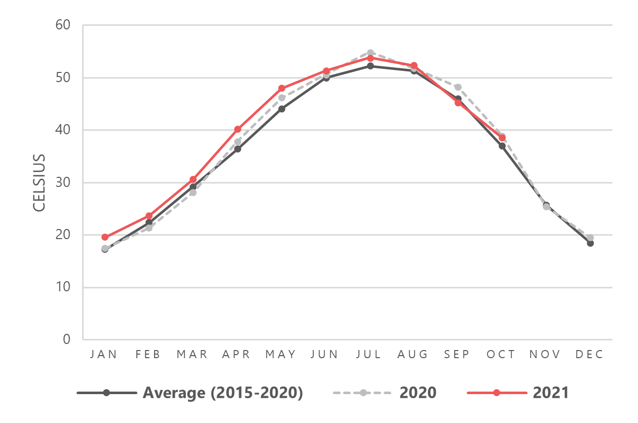
Figure 2 – Comparison of the average monthly temperature between the average of 2015 – 2020; average of 2020; and January-October 2021.
This analysis identified geographic regions and population groups most likely to be impacted by temperature and precipitation changes specifically. However, access to water of sufficient quantity and quality is affected by a range of factors, including but not limited to water salinity and pollution, which may alter the vulnerability profile of households in different areas of Iraq. REACH Initiative is currently exploring additional products to provide a comprehensive understanding of the climate-related challenges affecting Iraq.
More info in the Precipitation and Temperature Change in Iraq – November 2021 brief.
09/12 – South Sudan – Understanding cumulative effects of conflict and flooding on food security, coping capacity, and social stratification in Canal-Pigi county
Since the Integrated Phase Classification (IPC) workshop in November 2020, the cumulative effects of conflict and flooding have left Canal-Pigi facing Emergency (IPC Phase 4) levels of food insecurity projected until July 2021.
Canal-Pigi County has seen continued flooding since August 2020 and, at the time of the assessment, remained flooded with flood waters unlikely to recede soon. The flooding reportedly resulted in large-scale unseasonal internal displacement from low-lying areas into highlands mostly near the north of the county. Displacement to larger towns has further added pressure of an increasing internally displaced persons population on host communities’ resources, with the limited maize harvest and humanitarian food assistance provided being shared with the IDPs. In light of these recent shocks, REACH conducted a rapid assessment in Canal-Pigi in October 2021, to investigate whether humanitarian conditions have deteriorated.
Key Findings
- Focus group discussion (FGD) participants commonly reported that the food security situation was worse than in previous crisis years. This is reportedly due to a combination of factors, including the compounding effects of two years of consecutive flooding in 2020-21, increased insecurity incidents, reduced ability of households to plant key crops (such as sorghum), and a limited number of households that had received humanitarian food assistance over the past year. Flooding has led to widespread collapse of livelihoods, severely affecting the ability of households to cultivate and maintain livestock, and decreasing community and household coping capacities.
- Flooding has led to widespread collapse of livelihoods, severely affecting the ability of households to cultivate and maintain livestock, and decreasing community and household coping capacities. Canal-Pigi is situated within the Eastern Plains Sorghum and Cattle livelihood zone, where livelihoods depend on cultivation of sorghum and livestock rearing in a normal year. As flood waters remained high during the dry season in 2021, very few households were reportedly able to plant any crops and no sorghum harvest is expected in 2021.
- In addition to reliance on fishing and wild foods, FGD participants reported that community members were engaging in extreme coping strategies such as begging, restricting consumption of adults, only eating one meal per day, and skipping meals for consecutive days.
- Humanitarian service providers reported that provision of aid has been challenged by the floods, with disruptions and delays in services. Flooding and insecurity have also created several barriers for communities to access humanitarian food distribution points.
Find out more about the October 2021 assessment on Compounding Shocks and Consequences for Food Security, Coping Capacity, and Social Stratification in Canal-Pigi county.
08/11 – REACH conducts a flood hazard assessment in northwest Syria where IDPs have been experiencing recurring winter flooding
In northwest Syria winter storms have the potential to generate devastating floods which have a disproportionate effect on internally displaced persons (IDPs) living in camps and informal sites. Recurrent heavy rain between 14 and 31 January 2021 generated widespread flooding throughout northwest Syria, affecting an estimated 122,953 internally displaced people (IDPs)1 and resulting in the death of a child and injuries to three other individuals. More than 300 camps and sites throughout the governorates of Idleb and Aleppo were impacted by the floods, 8400 shelters were reportedly destroyed, while a further 13,800 shelters suffered some level of damage. Thousands of households were forced to seek shelter in schools, mosques and open spaces where winter temperatures dipped below freezing.
Winter flooding within IDP camps and sites throughout Idleb and western Aleppo has been a recurrent problem for several years, the recent devastation suffered by vulnerable populations in these locations is tragically only the most recent example following many similar previous events in the past. In November 2016, camps in Dana sub-district were impacted by flooding which inundated tents and accessways causing destruction of property and movement difficulties. In December 2018 another severe storm resulted in widespread flooding throughout Idleb and Aleppo, and damage to tents and property was reported in more than 60 camps. Again, in March 2019 heavy rainfall caused severe flash flooding in the region, damaging road infrastructure and destroying food stocks. In June 2020 heavy rain in Ma’aret Tamsrin, south of Dana sub-district, caused severe flooding, resulting in the loss of three lives, and reportedly destroying hundreds of shelters and putting sanitation facilities out of service.
IDPs are among the population groups most vulnerable to the impacts of disasters associated with natural hazards for a number of reasons. The primary reasons are linked with the locations and living conditions of the sites where IDPs live. IDP sites and settlements are frequently located on land that has traditionally been considered uninhabitable due to environmental factors such as steep terrain, rocky or arid ground, or land that is known to be prone to seasonal flooding. Moreover, IDPs in camps and informal sites often live in densely populated environments and in shelters that are not designed to resist natural hazards.
In addition to the immediate hazard flash floods present to people and property, poor drainage and persistent standing water in and around shelters can lead to numerous health and sanitation problems in camps and informal sites extending the adverse effects of flooding beyond the event itself. Lastly, the current outbreak of COVID-19 and the rising number of confirmed cases in northwest Syria, add to the particularly concerning situation in the camps and informal sites this upcoming winter.
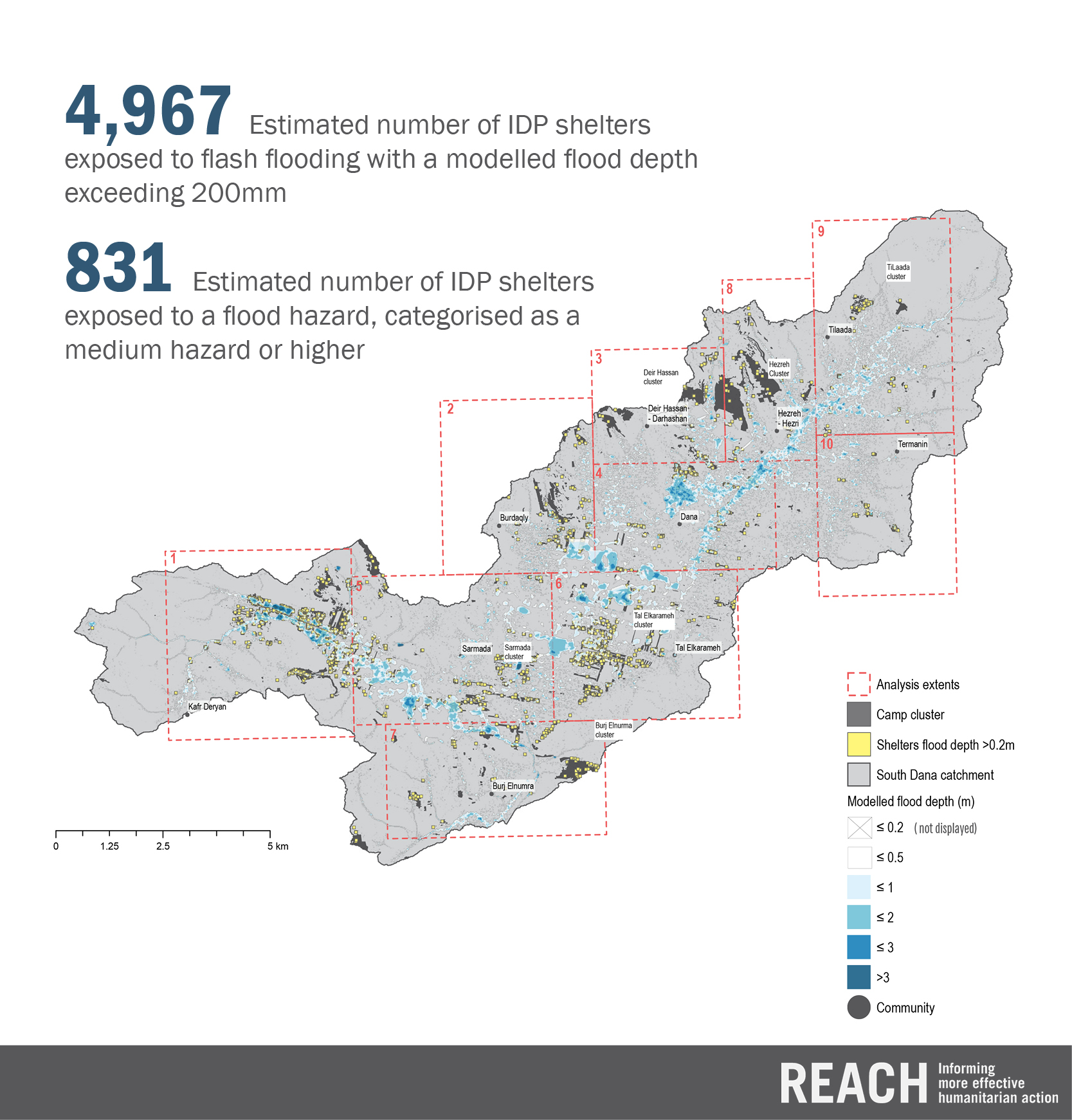
Key findings regarding the catchment of southern Dana sub-district which includes the densely populated Kafr Deryan, Tal Elkarameh, Dana, Sarmada, Burdaqly and Tilaada camp clusters. Numerous camps within these clusters have experienced severe flooding on multiple occasions since 2016.
- The assessment utilised HEC-RAS hydraulic modelling software to estimate flood depths and velocities during a heavy rainfall event within the catchment. The results have been analysed to highlight shelters located within IDP sites which may be most susceptible to flood hazards.
- The assessment detected 4,967 IDP shelters exposed to flash flooding with a modelled flood depth exceeding 200mm.
- The assessment detected 831 IDP shelters exposed to a flood hazard modelled (depth x velocity) categorised as a medium hazard or higher.
- Kafr Deryan, Tal Elkarameh, Sarmada and Dana considers as the most affected communities and clusters in south Dana subdistrict where the flood simulation computed 4,138 IDP shelters exposed to flash flooding in combined.
- The nature of the south Dana catchment as mountainous at the edges and flat plains in the middle made it more exposed to flash floods and increase the velocity of water running down toward the plains.
Learn more by reading the flood hazard assessment undertaken by REACH, highlighting shelters located within IDP sites which may be most susceptible to flood hazards.
27/07 – South Sudan – In Jonglei state, 2020 flooding impacts on shelter surpassed those of 2019
The October 2020 to July 2021 Integrated Food Security Phase Classification (IPC) analysis results showed that Jonglei state has faced Phase 4 Emergency levels of food insecurity as of October, a crisis that has been in part driven by high levels of flooding in both 2019 and 2020. The REACH team conducted interviews with Key Informants (KIs) who had recently arrived from, recently visited, or received regular information from a settlement or “Area of Knowledge” (AoK), to assess the flooding impacts on shelter and displacement dating back to August 2019.
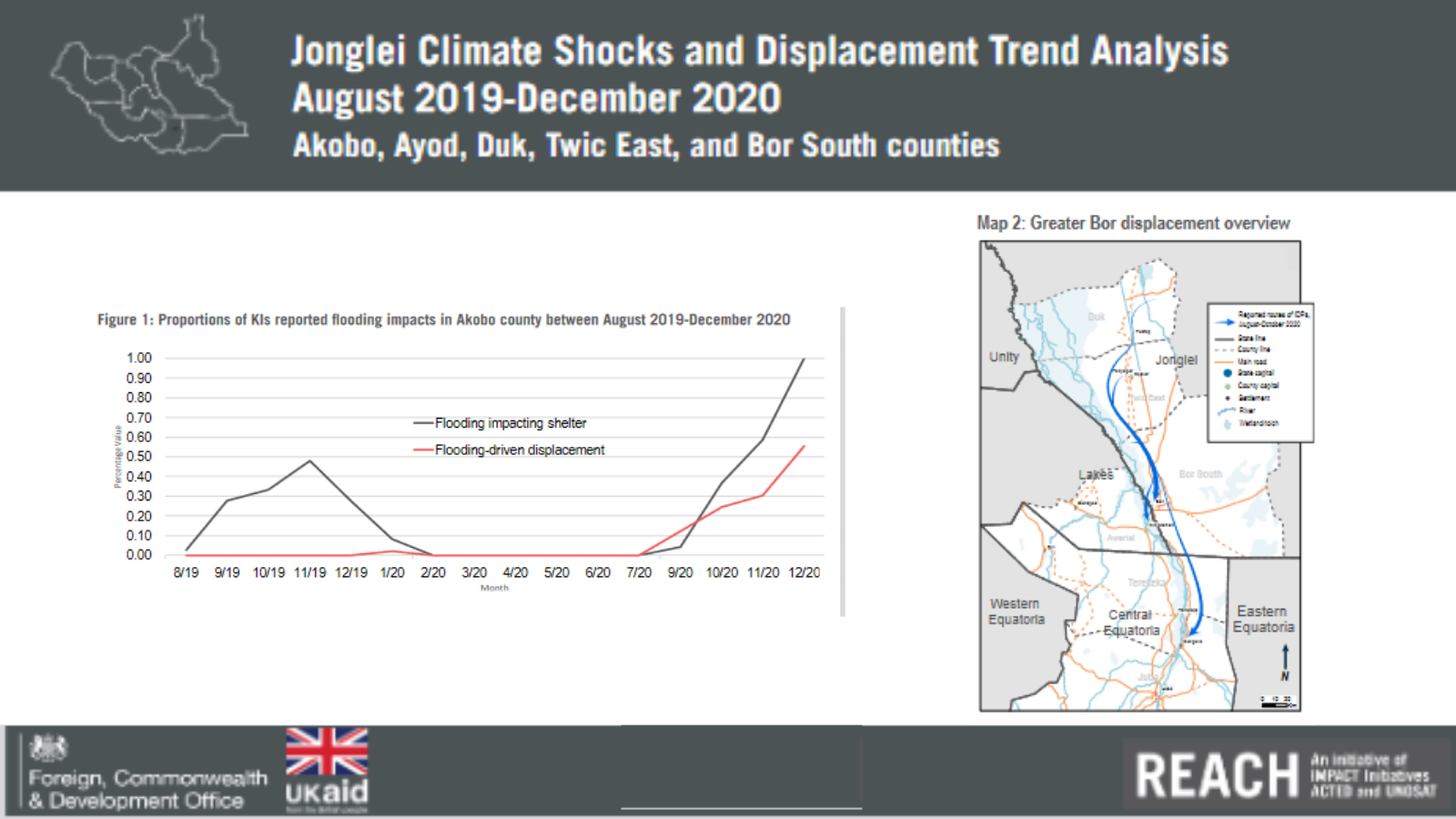
The findings showed that:
- in each county of analysis, 2020 flooding impacts on shelter surpassed those of 2019, with the amount of KIs reporting flooding forcing people to leave their residence at a significantly higher rate.
- Twic East county saw some of the most concerning flooding impacts, with the highest proportions of KIs reporting flooding-driven displacement of the five counties.
- Akobo county saw the highest proportion of KIs reporting displacement caused by any displacement driver or combination of drivers in a single month in December 2020, when flooding combined with other compounding shocks surged
More info in the Jonglei Climate Shocks and Displacement Trend Analysis Brief
09/06 – Somalia – Effects of Drought and Conflict on Households in Southwest State (SWS)
In 2020, Somalia endured a confluence of adverse, compounding shocks, which imposed significant tolls on a population already living under hardships of previous years. Already at the start of the year, Somalia was experiencing high rates of poverty – more than half of the country was estimated to be below the poverty line – as well as diminished agro-pastoral production, protracted displacement for significant segments of the population.
Beginning in 2019, the country experienced two overlapping locust swarms, which inflicted a high cost on farmers and herders and further imperiled food security and nutrition. A March 2020 rapid needs assessment estimated that 55% of farming land and 50% of grazing land had been affected by the swarms, a cause of concern in a country where, among the rural population, 50% of households are pursuing agro-pastoral livelihoods and the other 50% nomadic pastoral ones. By July 2020, it was estimated that as a result of locusts, along with other pests and flooding, the Gu season harvest could be as much as 15 – 25 percent lower than the long-term average from 2016-2019. The possible effects of diminished food production were already being observed, as, a 13 percent increase in new monthly admissions of acutely malnourished children was observed between January and March 2020
Somalia experienced an above-average rainfall from the Gu rains, which occurred from April to June, producing mixed effects for the population. The rains were vital for recharging subsurface water and relieving the existing water deficit, and were also attributed to improved harvest outcomes, the latter of which were especially critical in light of agricultural destruction by locusts. However, the heavy rains also contributed to significant flash and riverine flooding, beginning in April. The floods affected an estimated 919,000 people, including 411,905 of which were displaced, and others who experienced acute watery diarrhea or cholera.
The findings of REACH’s 2020 multi sectoral needs assessment (JMCNA) indicated that food security was particularly precarious in Southwest State (SWS
Households in Southwest State (SWS) have been particularly affected by the crises and shocks of the previous years, principally drought, insecurity, and flooding.
- SWS was found to have the highest proportion of assessed households (39%) facing extreme food security needs, almost double the national rate (21%). Across the state, among those households with extreme unmet needs in food security, needs were primarily driven by a dependency on friends/family or government and humanitarian agencies as their primary source of food.
- among the 44% of households in SWS not relying on tenuous sources of food, 89% were relying on a negative coping mechanism. Damage and disruption to infrastructure caused by recent flooding and conflict, along with disruption to humanitarian and government operations caused by COVID, has the potential to materially degrade existing living standards and deepen food security, nutrition, and health needs in the future.
As twin realities – the intensity of Somalia’s current needs and the unpredictable trajectory of major shocks and drivers of vulnerability – necessitates both short- and long-term humanitarian and development-oriented interventions informed by evidence, find out more by reading the report and factsheets of REACH’s 2020 multi sectoral needs assessment (JMCNA)
06/04 – South Sudan – Severe flooding causes the displacement of over 1 million people in 2020
The October-November 2020 Integrated Food Security Phase Classification (IPC) analysis determined that an estimated 50% of the population in Northern Bahr el Ghazal (NBeG) state were classified in Crisis (IPC Phase 3) or worse levels of acute food insecurity (AFI), with over 46% of children facing global acute malnutrition (GAM). Field reports and satellite data indicated that the high level of food insecurity and malnutrition encountered in NBeG was likely caused by a series of climate shocks, namely a combination of drought-like conditions in July followed by flooding in August/September 2020, both of which affected the harvest. Severe flooding across South Sudan has caused temporary displacement and disruption in service provision to more than 1 million individuals in 2020 (OCHA).
To support the understanding of food insecurity levels and the status of distress migration in the area, REACH conducted a qualitative assessment in Northern Bahr el Ghazal state to reveal the intricacies and impacts of the climate shocks as well as investigate reports of atypical displacement. These findings were then triangulated with recent satellite imagery analysis.
To inform the humanitarian response to the 2020 flooding and future disaster risk reduction efforts, building on methodologies developed by REACH for Yemen and Central African Republic, UNOSAT produced the first ever country wide flood susceptibility analysis and mapping for South Sudan. The criteria used include elevation, slope, topographic wetness index, rainfall intensity and duration (average maximum annual), distance from nearest drainage, height above nearest drainage, land-cover and soil type. The spatial resolution of the flood susceptibly analysis is 30 meters for the complete country.
Key findings:
- In 2020, a combination of climate shocks had a severe impact on food production. Delayed rains and drought-like conditions between May-July, followed by flooding from July-September interrupted the typical cultivation calendar. Dry conditions meant households had to delay land preparation and seed planting, which led to reduced crop health and growth. Subsequent flooding meant that a large amount of crops were destroyed, with many that could be salvaged impossible to cultivate due to delayed planting.
- Households were frequently using food-based coping strategies such as skipping meals, with foodstocks reportedly almost exhausted. This level of food insecurity is uncommon for this time of year, with the lean season usually between May – June before the harvest in July, suggesting food security conditions may deteriorate further before the next harvest. In addition, access to traditional livelihood-based coping strategies such as crop rotation has been impeded by repeated climate shocks, with this having the potential to further exacerbate food insecurity.
- Flooding in 2019 reduced food availability, which was then exacerbated by a second year of climate shocks. This has meant many households have faced protracted food insecurity.
- Although movement of individuals seeking seasonal livelihood opportunities in Sudan is normal for parts of NBeG, atypical movement intentions of entire households to Sudan or areas on the border were commonly reported for the three months following data collection, and many households were already moving. Such atypical movements were reportedly due to food insecurity, which was compounded by high market prices, driving movements to access livelihoods such as fishing or casual labour, or humanitarian assistance. Movements of entire households were reported to likely take longer than typical seasonal movements.
- Many households remaining in NBeG are the least vulnerable households, that have the financial means to afford high market prices. However, while the households moving in their entirety are reportedly quite vulnerable, among the most vulnerable households are those that are remaining behind because, despite having few assets or other means to cope locally, they are unable to make the journey, especially those with household members who are elderly or Persons with Disabilities and those who do not have the financial means to afford transportation by vehicle.
- Most respondents felt that rainfall had become more irregular in recent years. Many said that, if they were to experience climate shocks driving food insecurity similar to those in 2020 several years in a row, they would pursue longer-term relocation from their area.
For more information, the Climate Impact & Displacement Profile fact-sheet for the Northern Bahr el Ghazal state is available online.
04/03 – Ukraine – When climate change compounds conflict: the fight against wildfires in Eastern Ukraine
The full version of this blog-post is available here.
The impacts of climate change In Eastern Ukraine are becoming increasingly clear as the frequency of natural hazards such as droughts, heat waves, dust storms and wildfires continue to rise. In summer and autumn last year, drought conditions resulted in major wildfires in Luhansk oblast, damaging 500 homes and leading to 11 deaths in 32 settlements across the region.
These climate risks severely compound an already precarious situation in a region that has been suffering from the effects of a protracted conflict since 2014. Frequent shelling, land mine fields, and the contamination of unexploded ordnance in the Luhansk forest belt, which has been intersected by the conflict`s contact line since 2014, make the area extremely susceptible to wildfire risk, as highlighted in the IMPACT area-based risk assessment for Popasna raion. In addition, the area is heavily industrialised and decaying infrastructure and disruptions to health care access further hinder resilience.
Across the wider Sea of Azov area, milder winters and reduced precipitation has also led to agricultural stress and reduced crop yields. Eastern Ukraine was not alone in facing the impacts of climate change, with major wildfires also occurring in the Chernobyl region in April last year. The forest fires in the Chernobyl region started in the exclusion zone close to the nuclear reactor, lasting for several weeks. Firefighting was complicated by frequent changes in wind direction and lack of roads, making vehicle access difficult in the response efforts. Polluted air from the fires was recorded as far away as Cherkasy, Poltava and Dnipro.
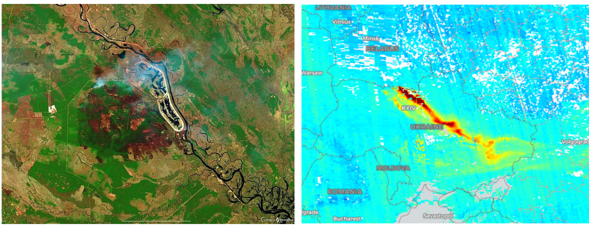
Left: Satellite image showing the extent of the forest fires in the Chernobyl region. Right: CO concentration across Ukraine. (Source: Sentinel-5P)
In such cases, prompt geospatial information to inform early warning, monitoring, and response to wildfires can make a difference in disaster prevention, preparedness, and protecting communities. Through the combination of satellite imagery and real time data from drones, remote sensing can be an effective and complementary way of providing essential information in wildfire response, in addition to providing added situational awareness and safety for response personnel which is crucial especially in the context of Eastern Ukraine.
Under the 3P Consortium project to Prepare, Prevent and Protect civilian populations from disaster risks in conflict-affected areas, IMPACT Initiatives provided ad-hoc mapping support to the Luhansk Emergency Service department during the wildfires. These maps helped to identify fire-affected areas through active fire detection and fire spread monitoring, based on satellite data from the Fire Information for Resource Management System (FIRMS) and information on critical infrastructure and vulnerable communities.
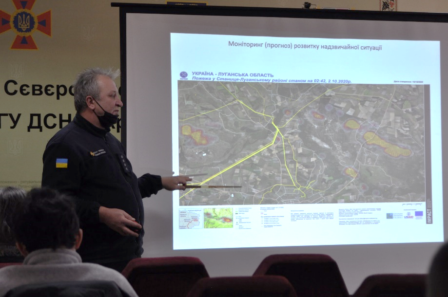
Oleksandr Hodyrev, Luhansk SESU Department, Head of the sector of preparation, training and organization of the emergency response presents IMPACT’s Active Wildfire Situational Overview Map to Oblast Response Unit team leaders.
In addition , IMPACT Initiatives provided the department with a drone and conducted training in geospatial analysis, highlighting the importance in the complementary use of drones and satellite data, such as that from the Copernicus Emergency Management Service, in wildfire disaster management.
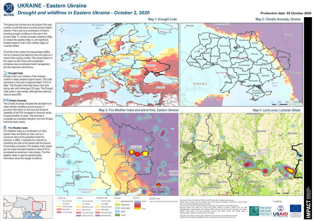
Regional Drought, Climatic Anomaly, Fire Weather Index, and Active Fires with Forest Cover along the Line of Contact in Eastern Ukraine highlighted to raise awareness and advocate for the severe conditions present.
A better understanding of disaster risks helps build awareness among affected populations, notably local communities, authorities, land planners, and state emergency services. Data feeds into the Disaster Risk Management cycle – not only to inform risk analysis but also to inform better preparedness, resilience, and response. This Ukraine example shows that the way in which data is collected and shared throughout the Disaster Risk Management cycle can make a vital difference in disaster prevention, disaster preparedness, and protecting first responders and communities in the event of a disaster.
Training conducted for Luhansk SESU unit in drone operation and geospatial analysis.
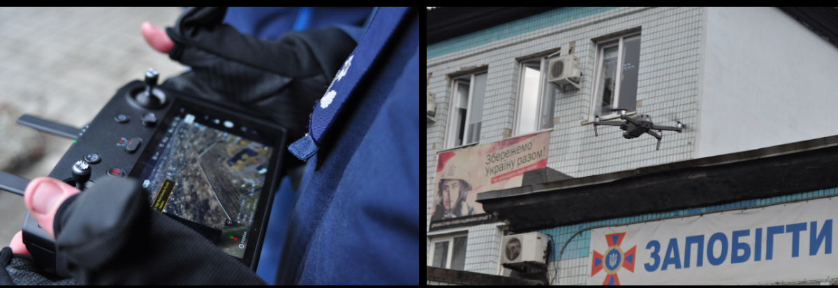
For more information, please feel free to download the full “IMPACT area-based risk assessment for Popasna raion” report.
05/02 – Syria – Shelters for Internally Displaced Persons (IDPs) in Northwestern camps are vulnerable to flooding
Click to access the full article published on this topic.
No time? Keep it short and simple in our twitter thread.
Displacement associated with disasters and the effects of climate change is one of today’s most serious humanitarian and development issue. In the first half of 2020 alone, disasters triggered 9.8 million new displacements, and most were linked to weather-related hazards such as storms, floods and droughts. In northwest Syria, extreme flooding events are devastating families already reeling from ten years of conflict, displacement, economic ruin, and the spread of the COVID-19 pandemic. Seasonal floods have become increasingly severe in the region, gradually eroding the resilience that communities have against ongoing and future shocks. Understanding the role of climate change, how it compounds the crisis in Syria, and what can be done about it, is critical.

Flood hazards are a product of flood depths and flood velocities. Deep water and high velocity flows pose a great risk to people and their property, particularly in situations where shelters, roads, and other infrastructure are poorly constructed or maintained. This is often the case in the informal IDP settlements in Northwest Syria where storms and floods have devastating effects for communities residing there.
The flood hazard mapping process utilized by the REACH Syria team involves several stages beginning with the delineation of catchments/watersheds and the definition of major overland flow paths and streams. Utilising SAGA terrain analysis, hydrology and channel tools to process Digital Elevation Model (DEM) data from the Japan Aerospace Exploration Agency, flow paths and catchments for the whole of Syria were defined.
In parallel the REACH Syria team in partnership with UNOSAT was working to identify IDP shelters from satellite imagery using a combination of machine learning detection algorithms and manual interpretation of imagery by analysts from the REACH and UNOSAT teams.
Using the high-level overland flow and catchment data and the IDP shelter locations, the team was able to overlay the two in order to identify areas where high IDP shelter densities lay in close proximity to major overland flow paths. Using this method, supplemented by numerous reports of flooding from local news agencies and CCCM cluster members over the past 5 years, the catchment of northern Dana was selected as the study area for a more detailed flood hazard assessment.
Simulating flood-like conditions in the northern Syrian context by feeding data into a hydraulic modelling software, REACH teams were able to evaluate locations within the area that were most exposed to severe flood hazards, and also identify which infrastructure and settlements were most vulnerable.
Results from the hydraulic modelling exercise revealed that during modeled extreme rainfall events, nearly 2,500 IDP shelters within the study area are exposed to a significant flood hazard.
26/01 – Sahel – Climate change, compounded by COVID-19, is pushing migrants to the brink
Click to access the full article published on this topic.
No time? Keep it short and simple in our twitter thread.
Described as a Ground Zero for climate change by the United Nations, the Sahel region hosts some of the most vulnerable populations in the world. Yet climate change is just one of the many challenges Sahelians are forced to contend with. Most regions face the dire consequences born from ongoing conflict, food insecurity, and political instability. The combination of these issues, further compounded by the spread of COVID-19 and the measures taken to fight it, act as threat multipliers in some of the most crisis-affected communities globally.
For Sahelian populations who traditionally rely on movement to sustain their livelihoods and meet their basic needs, measures taken to fight COVID-19 in the region as well as nefarious environmental impacts created by climate change have severely reduced their capacity to cope.
Mobility dynamics in the Sahel build on long-standing migration patterns developed over generations, often part of the livelihood strategies to cope with the seasonality of the climate.
Environmental migration patterns are central to populations in Niger & Burkina Faso where accessing additional livelihoods is vital to counter insufficient agriculture-based revenues, and lack of food, itself a result of unpredictable climate. This fine balance, between insufficient harvest yields and vital seasonal migration patterns to complement, has been severely disrupted by the pandemic. Movement restrictions, especially across borders, have had devastating effects for migrants in the Sahel.
Given the current circumstances presented by COVID-19 and increasing climate change trends, there exists a general lack of understanding of the complex linkages between these two phenomena and migration.
The freshly published report “Pushed to the brink? The impact of COVID-19 on environmental migrants in the Sahel”, conducted by REACH, in partnership with the Start Network as part of its Migration Emergency Response Fund (MERF) aims to increase this understanding- to offer better solutions for aid actors to respond to this crisis of mounting importance.
09/09/20 – Pairing satellite data with household surveys to locate high flood risk areas in the Central African Republic
Click to access the full article published on this topic.
In late 2019, a destructive flood event that occurred in the months of October and November in the Central African Republic (CAR) occasioned the displacement of over 100,000 individuals and caused considerable damage. Historically, inclement rains in CAR have destroyed shelters, obstructed transportation routes, and increased the incidence of diseases like cholera and malaria. The tropical climate of the country, characteristic during the rainy season, is exacerbated by climate change trends which lead to more frequent and destructive flooding of towns and villages. The unexpected nature of such natural hazards reduces the resilience that communities have against shocks, leaving them more vulnerable to the consequences.
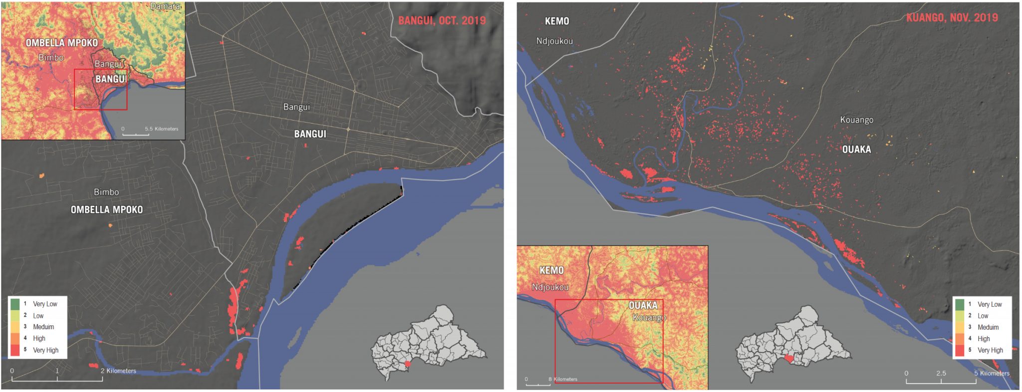
Flood footprint of the natural hazards that struck Bangui (left) in October 2019, and Kuango (right) in November the same year. Visual extracted from the accuracy assessment provided in the methodology output.
Through remote-sensing, REACH conducted a flood susceptibility analysis to classify areas within CAR that are more likely to flood, in an effort to inform enhanced preparedness. Results were then paired with indicators selected from the 2019 Multi-Sectoral Needs Assessment conducted across CAR, in order to develop a measure of relative consequential flood risk. The risk component accounts for where the impact on affected communities would be the worst, based on previously reported vulnerabilities. Based on needs and vulnerabilities reported by affected populations living in the most at-risk areas, the analysis showcased areas where the compounded impact of flooding would likely be the worst.
The analysis produced two outputs that are useful for planning response on the ground. First, a spatial representation of flood susceptibility, followed by a flood risk score for each prefecture and sub-prefecture assessed. Data revealed for example that the Ouham and Kemo prefectures have the highest flood risk, while Ouham Pendé and Nana-Mambéré prefectures have the lowest. These calculations are based on a combined measuring of exposure, vulnerability, and hazard to flooding.
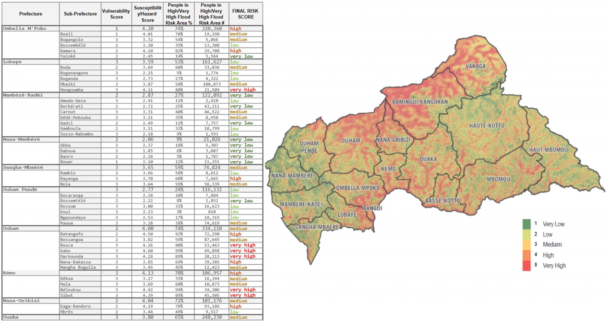
A combined measurement of pre-existing vulnerabilities reported in the 2019 Multi-Sector Needs Assessment with indicators affecting the risk of flood hazards enabled the identification of areas that were at high and very high risk to future flooding.
The flood risk score involved clipping the flood susceptibility layer to just the inhabited areas. This revealed that a significant portion of cities are highly susceptible to flooding. Many settlements in CAR are strategically located near rivers and tributaries which sustain the livelihoods of residents as a mode of transportation and means of sustenance. The banks of these waterways tend to overflow to accommodate the increasing amount of rainfall collected in these watersheds.
As a consequence, without any adaptation or contingency, the natural environment’s way of dealing with climate change will continue to impact affected populations, that are already suffering from conflict, and other shocks. The humanitarian community delivering assistance to affected populations in CAR must coordinate to mitigate the risks imposed by shifting climate trends. Failure to do so will inevitably impact the living conditions of entire communities, by diminishing their livelihoods and putting them at further risk.
22/01/20 – Climate change and natural hazards in Bangladesh show the need to focus on vulnerable populations
Click to access the full article published on this topic.
Living in a country where a quarter of the land is barely above sea-level, the people of Bangladesh are especially vulnerable to the effects of climate change and the havoc wrought by natural hazards. Those who live along the coastline are even more prone to the destruction brought by sudden-onset disasters, whilst a rising population density makes the risk reality for millions today.
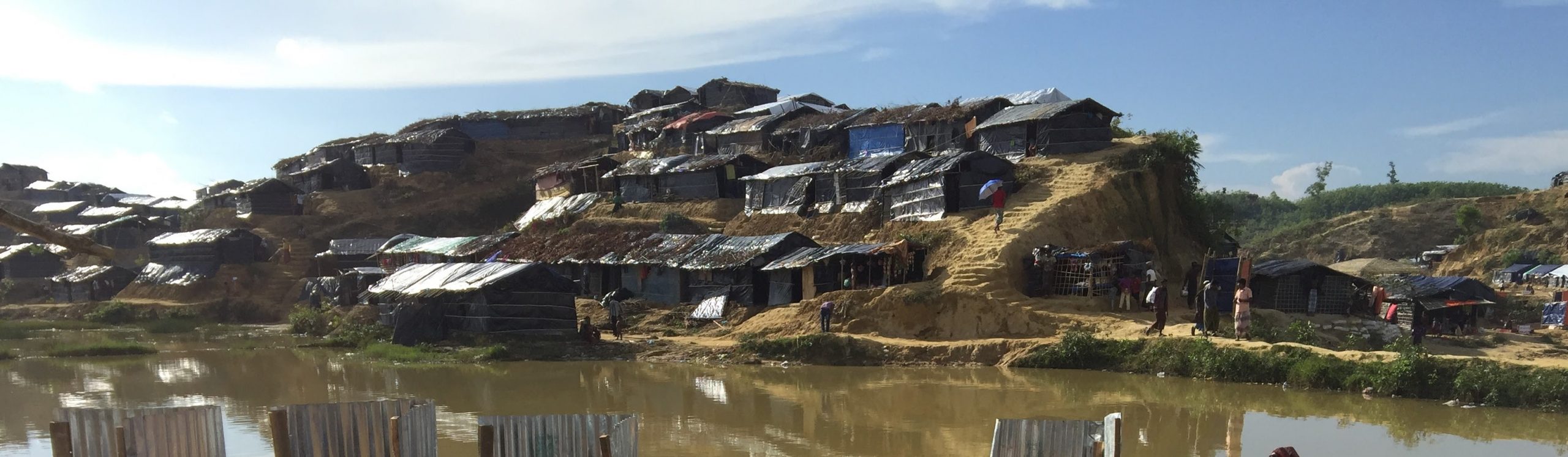
Picture taken by a REACH staff in a flooded district in Cox’s Bazaar.
Bangladesh has a history of devastating cyclones: at the end of 1970, the deadliest cyclone on record resulted in over 500,000 deaths; in April 1991, a devastating cyclone hit the Chittagong district of southern Bangladesh causing over 130,000 reported fatalities; and in 2007, the destruction brought by Cyclone Sidr led to another 3,000 causalities. While certain measures, such as the construction and use of cyclone shelters, have helped reduce the number of cyclone-related causalities, Bangladesh is unable to fully cope with the devastating consequences of disasters caused by natural hazards. Further compounding this complex and precarious situation has been the influx of Rohingya refugees in August 2017, leading to roughly 900,000 Rohingya refugees now living along the southern coastline of Bangladesh. Fear of the wreckage a powerful storm would cause across the refugee camps is a constant concern for responders on the ground as well as the Bangladeshi government.
In order to help populations most vulnerable to the effects of cyclones and other natural disasters, REACH has been working to establish a baseline understanding of population centers, natural hazards, the natural environment, and hazard mitigation measures in both host communities and refugee populations. Through a combination of assessments, mapping exercises, trainings, and as the co-chair of a subgroup of technical experts mandated under the Information Management and Assessment Working Group (IMWG) as the Natural Hazard and Risk Analysis Task Force (NatHaz TF), REACH has helped to collect, streamline, and standardize information- valorizing how it should be interpreted in Cox’s Bazar. The NatHaz Task Force is a dedicated sub-group of technical experts mandated with unifying, analyzing, and then disseminating digestible natural hazard information destined for operational actors on the ground.
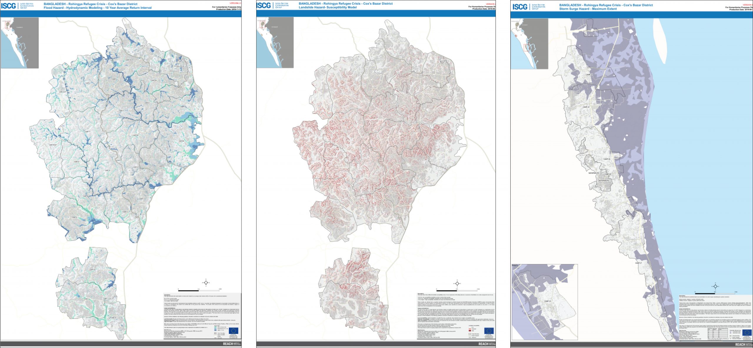
Left: REACH Flood Hazard map in Cox’s Bazar based on hydrodynamic modeling. Middle: REACH Landslide Hazard map in Cox’s Bazar based on a susceptibility model. Right: REACH Storm Surge Hazard map on the shores of Cox’s Bazar based on a maximum extent model.
Through continued coordination and capacity building endeavors, REACH facilitates information gathering and sharing to help improve Bangladesh’s ability to respond to natural hazards and to assist those most vulnerable to the effects of climate change.
17/05/19 – Assessing humanitarian needs after Cyclone Idai proved two things – the first was the importance of baseline data
Click to access the full article published on this topic.
Read our story-map on REACH’s response in Mozambique.
Natural hazards such as cyclones and heavy rains are becoming increasingly common on the southern shores of Africa. This trend driven by climate change was made visible in Mozambique where Cyclone Idai swept over the city of Beira and neighbouring provinces across to Zimbabwe. As extreme weather patterns become mainstream, the significance of data required to build preparedness is brought to the forefront of humanitarian action. So is the necessity for rapid response in assessing the needs of affected populations.
Between March 14th and 15th, Mozambique was struck by the culmination of a storm that had gained momentum over the region for the past weeks. When Cyclone Idai made landfall, it brought destruction and damage in its path. The urban areas of Beira, its port, and the rural regions in the surrounding Manica and Sofala provinces all felt the impact of the winds and rain. Idai caused substantial flooding and left entire communities submerged under water, bereft of shelter and in urgent need of assistance.
When Elliott Messeiller, senior REACH assessment officer part of the REACH deployment team, landed in Beira, the cyclone’s impact was visible at every turn. So was the lack of data. Response actors were hitherto forced to navigate with what little information they possessed. The gap between what was available and what was needed readily apparent.
From April 1st to 17th, two weeks after Idai swept across the country, REACH carried out a mapping and survey exercise across the hardest hit regions. The assessment reached beyond urban centres and main settlements to hard-to-reach areas that were only accessible by foot, boats or 4×4’s.
With the help of enumerators trained by REACH, household surveys were conducted to build the rapid multi-sector needs assessment.
Among the key findings from the multi-sector needs assessment:
- Food was the most frequently cited priority need by households assessed.
- At the time of data collection, crop lands were reportedly still flooded in 59% of assessed areas.
- 87% of flooded areas reported a substantial loss of crops and livestock, posing serious food security threats.
Access the full Rapid Multi-Sector Needs Assessment report published in Mozambique here.