

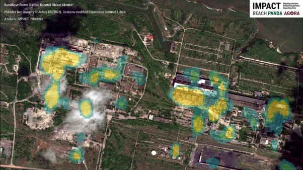

When disaster or conflict strikes, one of the first questions is also one of the simplest: where is the damage most severe, and where must aid actors focus first? For IMPACT, this question stems from over a decade of experience in damage assessment and remote sensing, particularly in humanitarian contexts like Ukraine and Syria. Very-high-resolution optical satellite imagery can help answer it, because it allows trained analysts to examine individual buildings and infrastructure closely. However, this process can be costly, often delayed, and too resource-intensive to cover hundreds of affected settlements at once.
That is why we have developed our in-house rapid radar damage screening method . The goal is not to replace the vital work done with optical imagery, but to make sure it is directed where the need is greatest.
Using open Copernicus Sentinel-1 Synthetic Aperture Radar (SAR) data, we compare how the ground reflects radar signals, the so-called “echoes”, before and after an event. Radar sees through cloud, smoke and darkness, and operates in any weather. Unusual changes in these echoes can point to areas where damage is likely and closer inspection is needed. What we produce is not a definitive statement that a given building is destroyed. It is a prioritization tool: a way to narrow a vast area of potential devastation before diving into detailed satellite image analysis, field verification, and other forms of evidence.
In the past four months, this method moved swiftly from research and development to real-world emergencies. After being developed and tested with our country office in Ukraine, it was deployed following the two recent earthquakes in Venezuela and the flash floods in Nepal, on 24 June and 26 August 2026 respectively. In total, 5,850 Sentinel-1 images were analysed, enabling the screening of nearly 15 million hectares across various contexts, including conflict zones, earthquakes, floods and landslides. The first product for Venezuela was delivered two days after the earthquake, and the first for Nepal within five days, in both cases constrained by when the first post-event Sentinel-1 image became available. This first phase relied entirely on open radar data, with no direct costs for cloud computing or outsourcing.
The Venezuela earthquake served as a crucial reality check for us. Multiple organizations came up with different damage estimates, each using their own sensors and methods. As the Humanitarian OpenStreetMap Team pointed out, the key question is not simply which figure is correct, but rather what each method reveals, at what stage of the response, and for which decisions. Based on an OCHA’s external assessment and internal validation, exercises IMPACT’s radar product performed well in ranking severely affected neighborhoods, but it could not reliably confirm damage building by building. That distinction is important, because evidence-based decision-making depends on understanding exactly what a dataset can and cannot tell us.
Our role within the wider disaster-data ecosystem is deliberately complementary. UNOSAT, the Copernicus Emergency Management Service, commercial imagery providers, Microsoft HASTE, HOT, local authorities, and field teams each hold a different piece of the puzzle. What we contribute is a lightweight, rapid, wall-to-wall damage screening layer that helps direct limited resources: where to request detailed imagery, where analysts and responders should focus their attention, and where verification efforts might be most beneficial.
The 2026 NASA Lifelines Ready for Impact program and its global network of senior experts helped sharpen this approach. Over a four-month incubator, we received critical feedback that pushed us beyond the algorithm itself: to define who our end users are, to quantify the time and cost savings, to clarify limitations, to ensure our solutions are user-friendly, and to align with established humanitarian geospatial standards and workflows.
Moving forward, our priority is not innovation for its own sake but proof that this works in practice to inform and prioritize follow up assessments. We need to minimize false alarms, combine open and commercial radar data with optical imagery, field evidence and AI-assisted analysis, validate our findings across various contexts, and shorten delivery times from days to hours when satellite availability permits. We also need our outputs to reach users through existing platforms, whether in protracted conflicts and recovery contexts or in the immediate aftermath of sudden-onset emergencies.
Our goal is not to document every event in detail from space, but to show responders where to look first, faster, across wider areas, with clear communication of uncertainty, and in close partnership with the broader conflict and disaster response community.
Want to find out more? Explore our experimental Venezuela Sentinel-1 damage screening dataset, the Nepal Sentinel-1 damage screening dataset and the associated rapid emergency situation report, as well as our recent pitch at the NASA Lifelines Ready for Impact showcase on 7 October 2026.